Tag Archives: seismic

New Data Available From UKOGL in Warwickshire: Daw Mill 3D Seismic & Borehole LAS Data

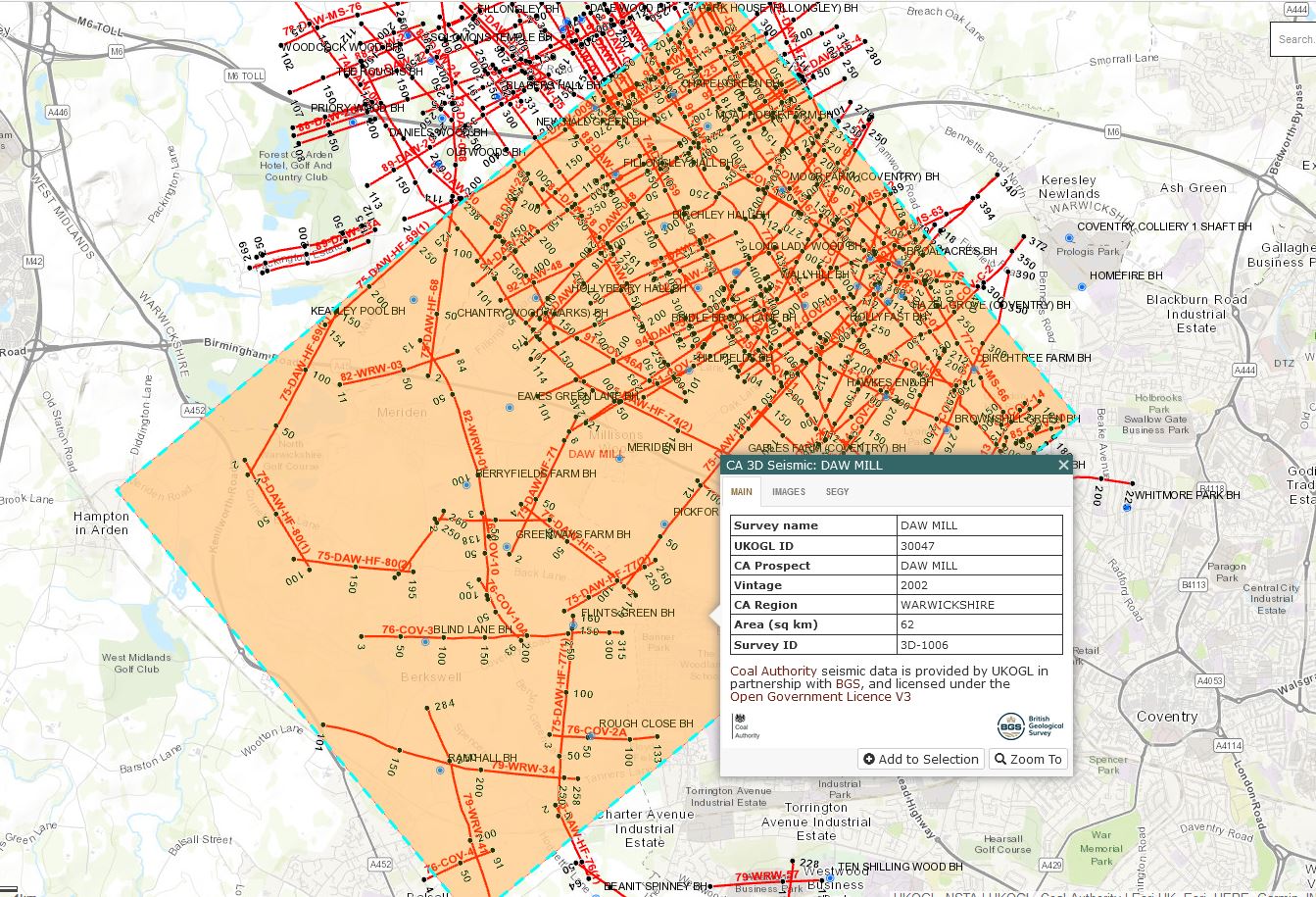
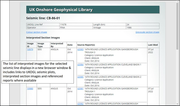
UKOGL are pleased to announce that post stack seismic data and digital LAS data located over the Daw Mill 3D survey in Warwickshire have been added to the UKOGL archive. The data is available to download via the UKOGL interactive map.

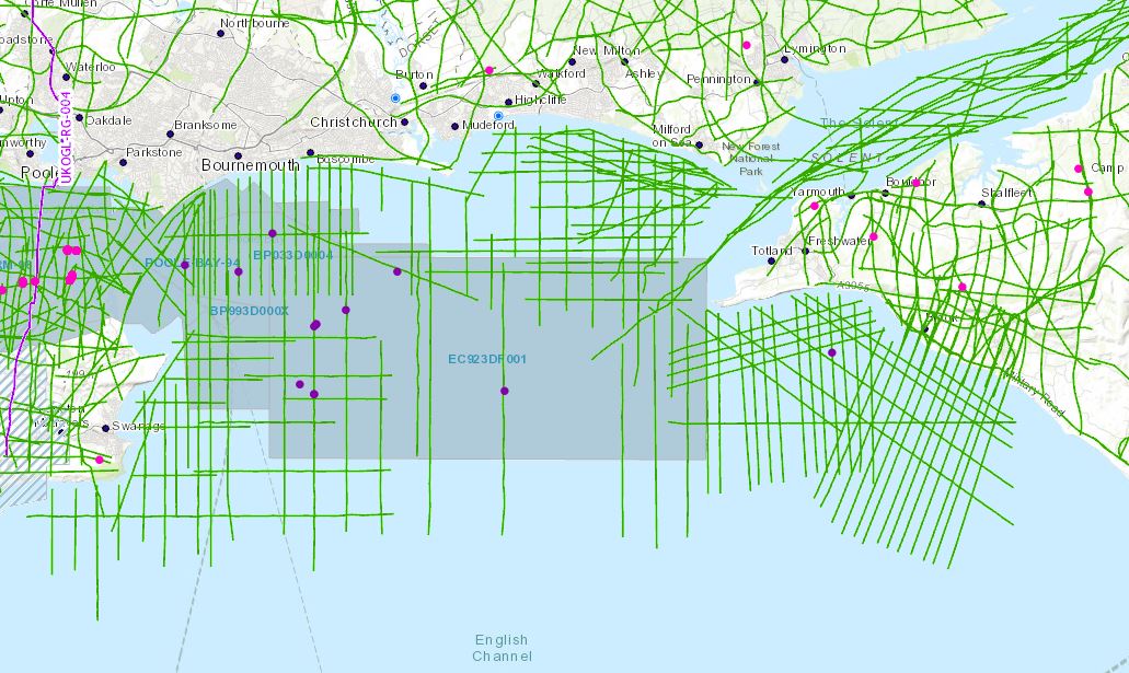
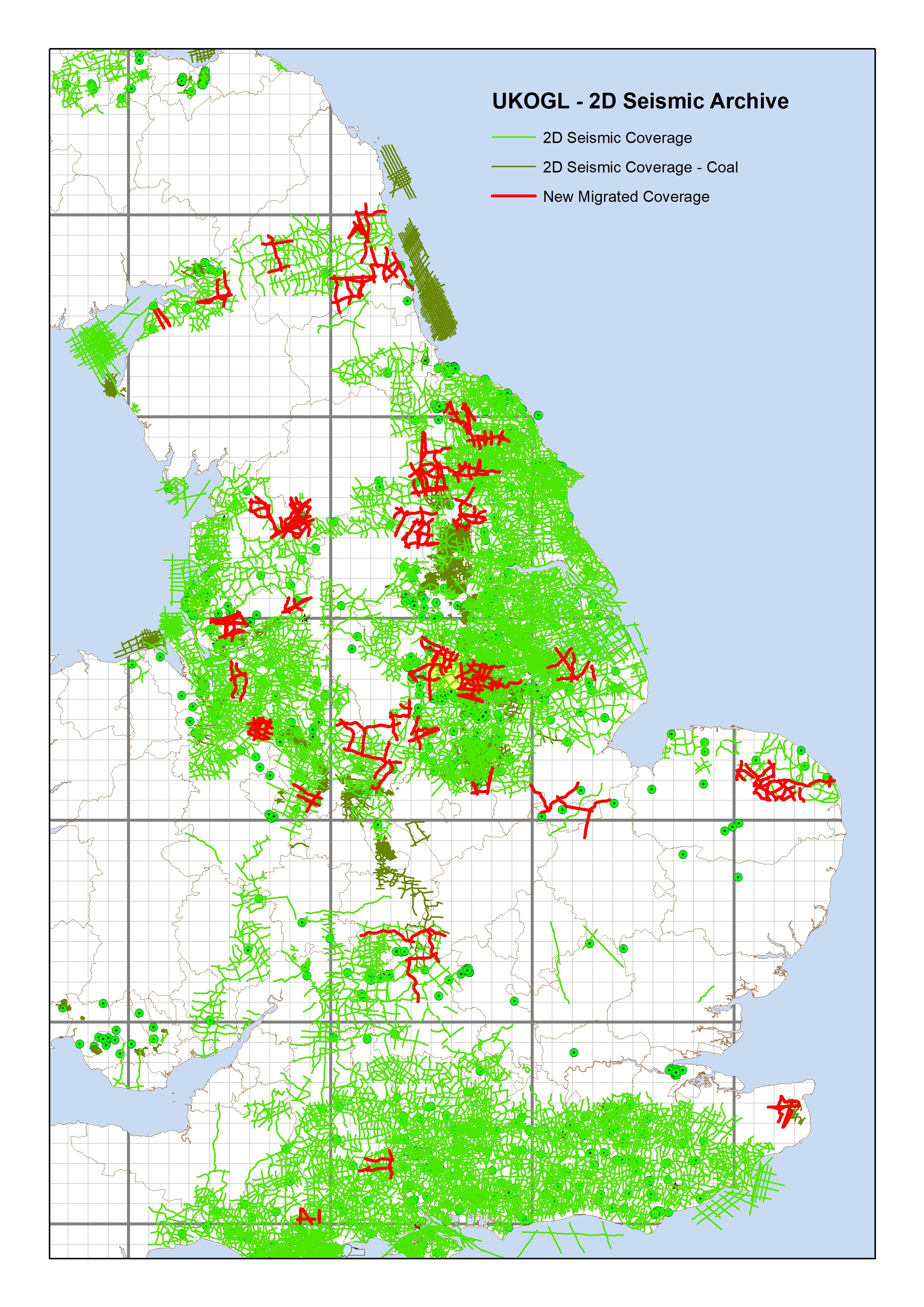
The new Coal Authority data over the area displayed in the map below can be accessed for free under the Open Government Licence.

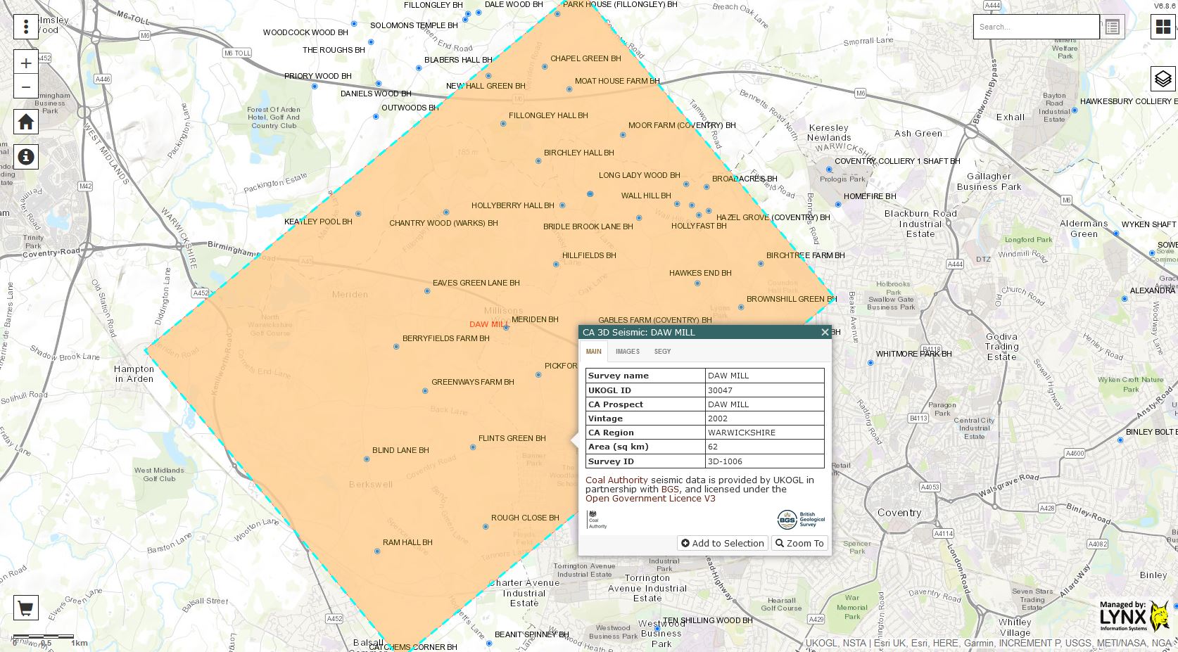
The available post stack data for the Daw Mill survey was originally recorded and processed in 2002, 2004, 2005 and 2011, expanding the coverage to the South West of the original 2002 survey with each subsequent year of recording.

The final 2011 merged and reprocessed post stack 3D data volume provides full seismic data coverage over the Daw Mill survey area.

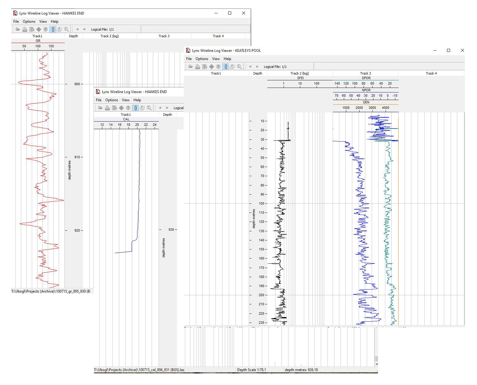
In support of the available 3D seismic, LAS data is available to download for 32 of the 37 coal boreholes that are currently displayed by UKOGL over the area of the Daw Mill 3D survey, and this includes comprehensive logging suites for the newly added Eaves Green Lane BH and Keatley Pool BH.

These two new data sets add to the coverage that’s already provided by the 2D Coal Authority seismic data over this area of Warwickshire (displayed in the map below). All Coal Authority data is available to download for free from the UKOGL interactive map.

Isle of Wight Offshore 2D Seismic Data now available from UKOGL

In support of the recent release of 2D, 3D seismic and well data located over Poole Bay, UKOGL have made available for download a selected set of data located offshore to the southwest of the Isle of Wight which provides greater coverage to tie this newly designated landward area to eastern onshore data. 11 of the 37 lines in the OX98-90 survey run onshore to enable seamless interpretation from onshore to offshore. The data set includes reprocessed 2D versions not available in the UK National Data Repository (NDR). 

Instructions on how to access this data can be accessed via the Poole Bay Blog post here.

The intention of this exercise is to make it easier for interested parties to study this key area of British Geology. Additional offshore 2D data is available from the NDR but coordinates will need to be transformed to OSGB to match.

UKOGL Seismic Data – Interpreted Images – Access, View & Download

UKOGL have implemented a new website feature that provides direct access to over 2400 interpreted onshore seismic images.

The interpreted images have been compiled and collated from reports currently held by UKOGL and can be viewed and downloaded  alongside  the seismic images that are already available for each onshore line on the website.

The interpretations may be based on pre- or post-drill prospect assessments and well results may have indicated that changes are necessary. For additional context please view the associated source reports where available, or the drill dates, finalised tops and times for any wells associated with the prospect

Neither the UK Onshore Geophysical Library nor the original interpreters warrant the integrity of these data and will not be liable in contract or in tort for any loss, damage or expense of any nature suffered by the user as a result of the use of, or reliance on, these data

The seismic lines that have interpretation images available can be selected and their locations displayed via the ‘Contents SideBar > UKOGL2D Seismic’ tab:

To access the available interpretations, highlight the displayed seismic line displayed on the UKOGL interactive map and then select the ‘Interpretation – view’ option where available:

A new window will open and display a list of all available interpretation images and associated source reports for the selected line:

Click on Image ID number to display the interpreted line; click on Source Report number to see the report from which the interpretation was extracted.

All available interpreted images can either be viewed on screen….

….. or downloaded and viewed outside your browser by selecting the ‘Download’ link on the listings screen:

2D Seismic Data Update – New Migrated Data Coverage

UKOGL have recently completed a project to improve the coverage of 2D SEGY format migrated seismic data available in UKOGL. Migrated hardcopy sections for 219 lines have been scanned and vectorised to SEGY and are now available for release. The lines were selected to ‘infill’ areas that previously lacked migrated SEGY data coverage.

The image below displays the 219 lines selected over England overlaid on top of the complete 2D onshore seismic coverage available through UKOGL.

The image below displays the new 2D data set (red lines) that improves and complements the comprehensive 2D migrated coverage (purple lines) already available in UKOGL; infilling areas that previously had limited SEGY format migrated data.

Please contact UKOGL for more information about the new update to the post stack SEGY archive or for any other questions that you may have about UKOGL.

The migrated hardcopy sections were scanned and vectorised by Lynx Information Systems, output to SEGY and are now ready for workstation loading.