
Licence Relinquishment Reports – Data Release
UKOGL has made available a new batch of onshore Licence Relinquishment Reports, supplied to the NSTA and released for download via UKOGL, the onshore licences covered are:
PEDL118, PEDL191
PEDL201, PEDL202, PEDL203
PEDL306, PEDL334
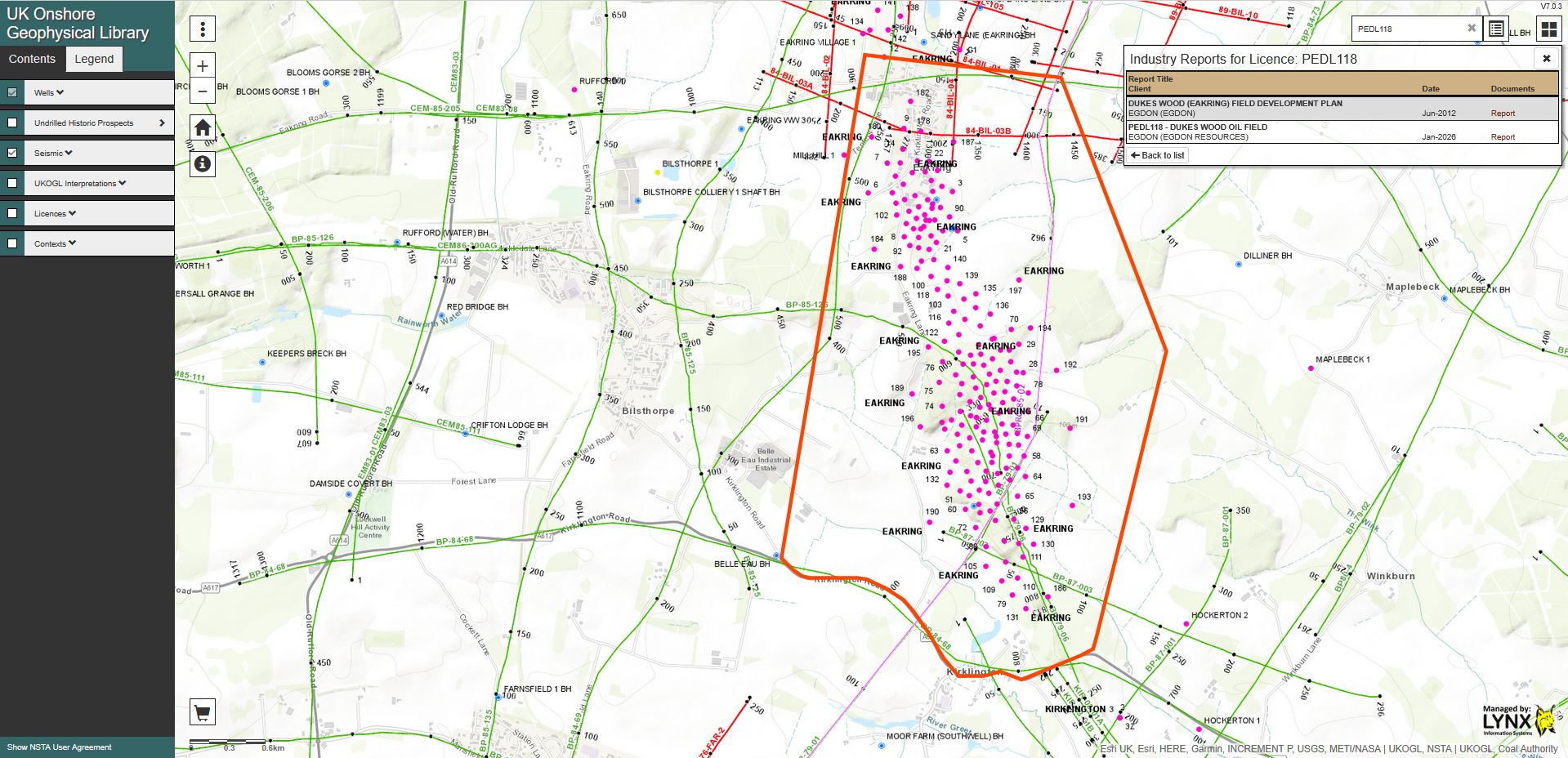
Each report can be accessed using the search option on the interactive map or via the UKOGL ‘Industry Activitiy Reports’ web page.
UKOGL makes available field statics reports from onshore seismic surveys
UKOGL is pleased to announce the addition of field statics reports, most compiled in the 1980s by a group attached to Leeds University, to the data freely downloadable from the website (www.ukogl.org.uk). Whereas the processed seismic data do not normally resolve the near surface, these statics data include valuable information on near surface geology and velocities and may be of assistance in studies on slope stability, collapse features and major engineering projects.
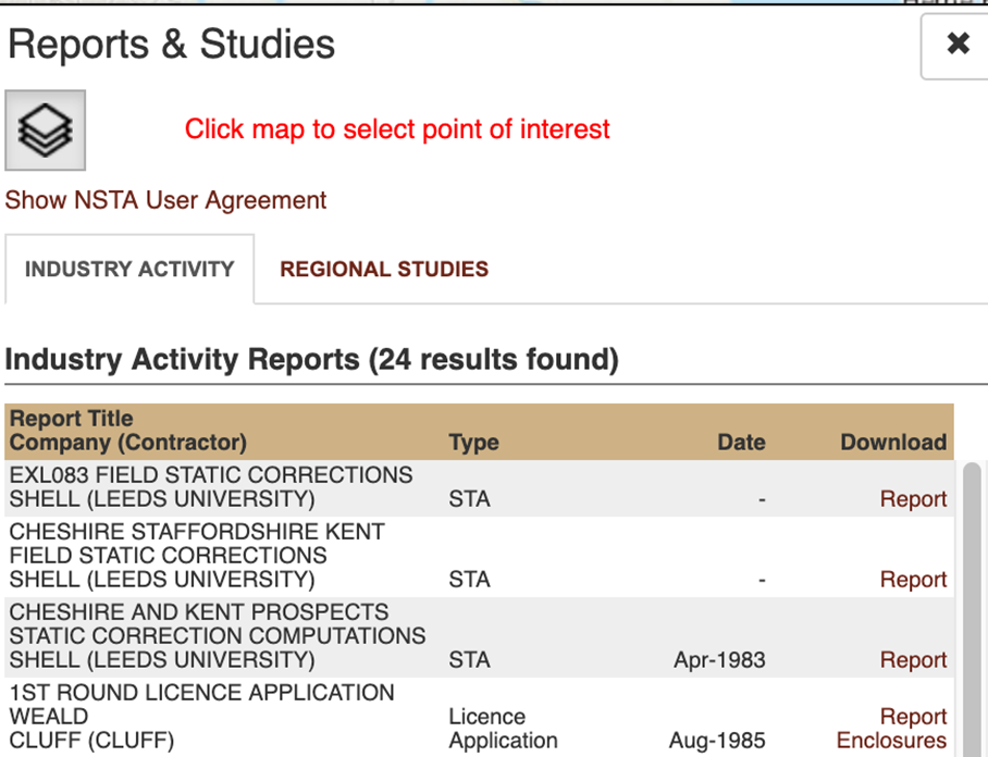
Reports are filed by seismic survey campaigns, which may cover several different licence areas, and can be accessed by clicking the Reports button on the website

Then clicking on the area of interest. Example results are shown below:
UK Onshore Relinquishment Reports Release
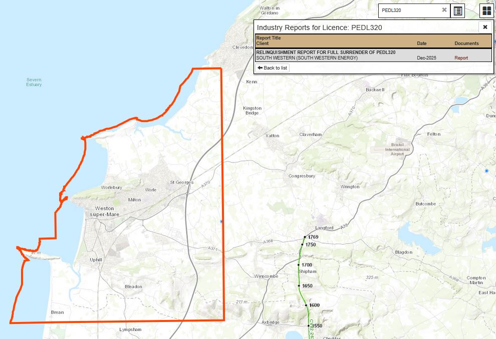
UKOGL have uploaded and made available for download eight onshore Licence Relinquishment Reports in January 2026. The reports have been supplied for release by the North Sea Transition Authority (NSTA) and are located over the onshore PEDL’s listed below:
PEDL012 – Star Energy Group Plc
PEDL261 & PEDL262 – Aurora Energy Resources Limited
PEDL320, PEDL321, PEDL327, PEDL329 & PEDL344 – South Western Energy Limited
UKOGL makes major additions to its online oil and gas well archive
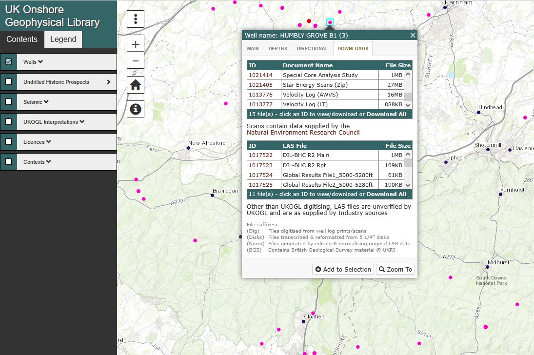
UKOGL is pleased to announce that it is in the process of adding the entire archive of scanned paper well logs and reports from UK onshore oil and gas wells which Star Energy has recently provided to the NSTA. The archive comprises data from 812 wells and these data are being provided for each well in the form of a zipped file (labelled “Star Energy Scans (Zip)”) in the list of files under the “DOWNLOADS” tab of the drop-down menu that is accessed by clicking on the relevant well on the UKOGL website.
As part of this major well data release exercise, UKOGL is also uploading scans of logs, reports and other information donated by various companies over the past 30 years and held on file. These data include core photos and analysis, geochemical and paleontological reports, VSP reports, testing reports, etc. and are available as separate items in the “DOWNLOADS” and “BP ARCHIVES” listings.
This major undertaking is still in progress and as of 20 March 2025 new data had been uploaded for 430 wells. UKOGL would like to record its thanks to Star Energy for making these data available for publication.
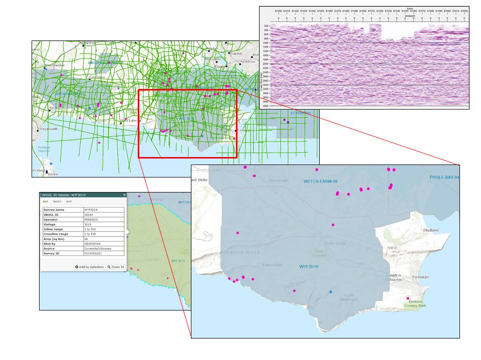
2025 – UK Onshore Seismic Survey Release
The UK onshore seismic survey WYF3D19 and associated supporting data is now available to access from UKOGL following the end of the proprietary period.
Originally recorded in 2019 by Perenco, the 86km2 3D survey provides additional seismic data coverage over the Dorset South coast with the 1998 Wytch-Farm-98 3D survey situated to the North and Poole Bay located to the East.
Survey data is available for both commercial and academic use (subject to applicable licensing and output charges). Further information about the survey and access to the data is available via the UKOGL website and interactive map.
UKOGL provides further LAS files decoded from legacy STAR tapes
UKOGL is pleased to announce that Star Energy Group has kindly given it access to tapes containing legacy data from UK Onshore wells. These files have been transcribed by Ovation Data and Lynx Information Systems at UKOGL’s expense and have provided LAS files for 33 wells for which no data were previously available to UKOGL and a further 48 wells for which only partial data were previously available. All new data have now been uploaded to the UKOGL site (www.ukogl.co.uk) and are available for free download.
Separately, UKOGL has digitised logs of Guiting Power-1 and Winterborne Kingston-1 to generate LAS files. These are also now available for free download.
UKOGL – Deepwood Mining Data – important records rescued from a quarry building.
UKOGL Trustees are pleased to announce that we have recently completed the archive and release of previously unavailable pre and post-stack digital data sets from a number of Deepwood Mining exploration surveys, located onshore in the SW Pennines, 40 years after they were recorded.
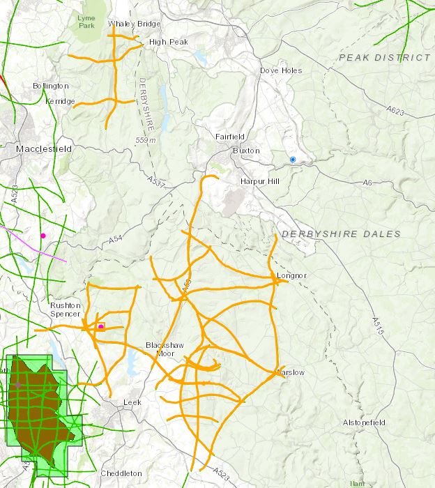
These original digital seismic data sets were not available to UKOGL when prints of seismic lines were scanned and vectorised for archiving in 2005.
The Trustees would like to thank the British Geological Survey for their assistance in rescuing these data and making them available for archive. The data had been stored in very poor conditions for many years and this was reflected in the state of the media when supplied to UKOGL. Data rescued consisted of a range of media formats, including 9 track magnetic reels, hardcopy paper and sepia sections, navigation plots and contoured base maps. A large proportion of the hardcopy paper and sepia media was damp and covered in mould, having to be dried out and cleaned before any attempt could be made to assess and archive.
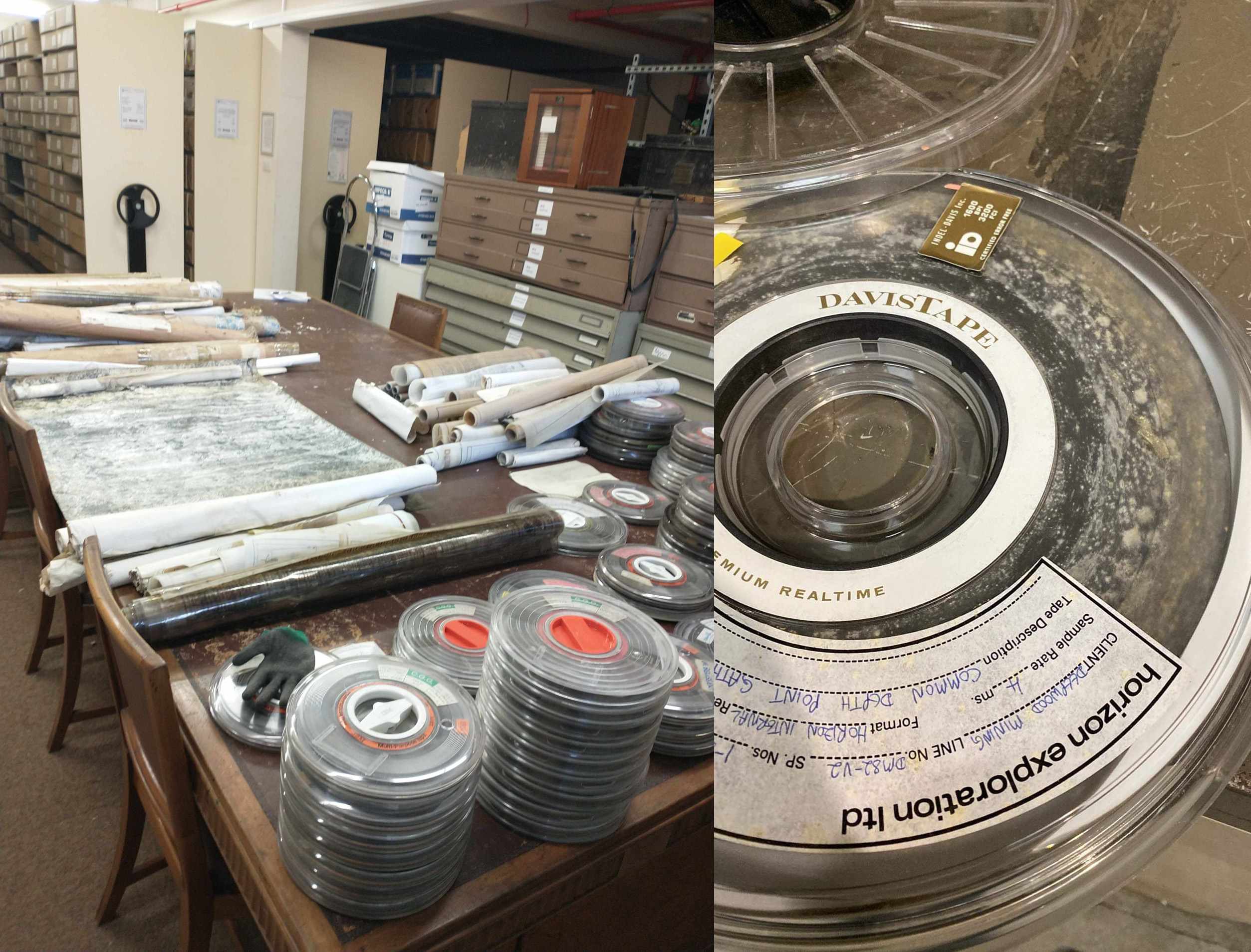
The 9 track magnetic reels were in a similar condition and were sent out to Ovation Data for stiction treatment and transcription in order to maximise the data recovery process.
Despite the very poor condition of the data, a large proportion has been recovered and is now available from UKOGL. Please contact us for more information.
Geological Society – Energy Group Award – 30 years of UKOGL
UK Onshore Geophysical Library is pleased to announce that Dr Malcolm Butler has been awarded the 2024 Geological Society Energy Group Medal for his significant contribution to the success of UKOGL from its initial inception in 1994 to the present day.
Developed in conjunction with Lynx Information Systems, UKOGL has been recognised as providing an ‘easy to use’ online experience enabling access to a continually increasing range of historic geophysical and geological data that it has supplied extensively to academia, industry and the general public over the past 30 years.
The data sought out, verified and archived by UKOGL were originally recorded in the exploration for oil, gas and coal onshore in the UK, but are now being repurposed for academic and commercial research into the development of geothermal energy, long-term storage of nuclear waste, Carbon Capture and Storage and the underground storage of Hydrogen.
More information about this award can be found here.
UKOGL Onshore Map: Wells Layer – New Search Option
UKOGL have added a new filter option to the Wells layer of the Interactive Map to helps users when searching for UK onshore data. The wells displayed on the map can now be filtered using the ‘UKOGL last updated since’ option to only display the wells that have had new or updated data added to the site since the user defined date.
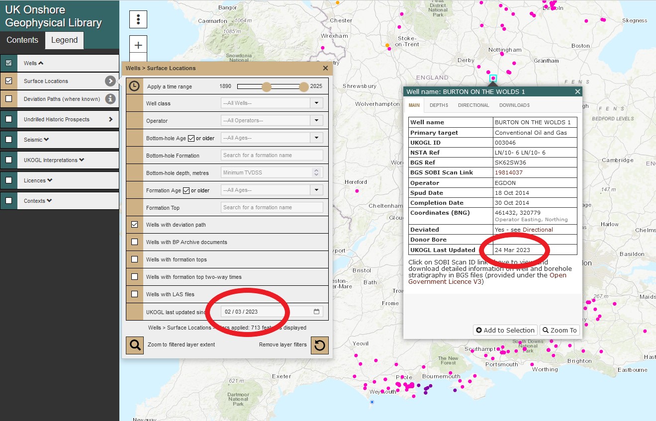
Wells that haven’t had any new data added after the user selected date will not be displayed. The new filter option can be also be combined with other available search options to further refine a query.
UKOGL provides listing of bottom hole temperatures measured in wells drilled for oil & gas in the UK Onshore
UKOGL has generated a listing of 1,838 temperatures vs depths recorded by logging runs and testing from well data for UK Onshore wells. The listing can be downloaded in Excel format from UKOGL here. Note that downhole temperatures from logging runs are generally recorded shortly after drilling mud has been circulated and the readings are likely to be lower than actual formation temperatures.