Category Archives: Wells

UKOGL makes major additions to its online oil and gas well archive

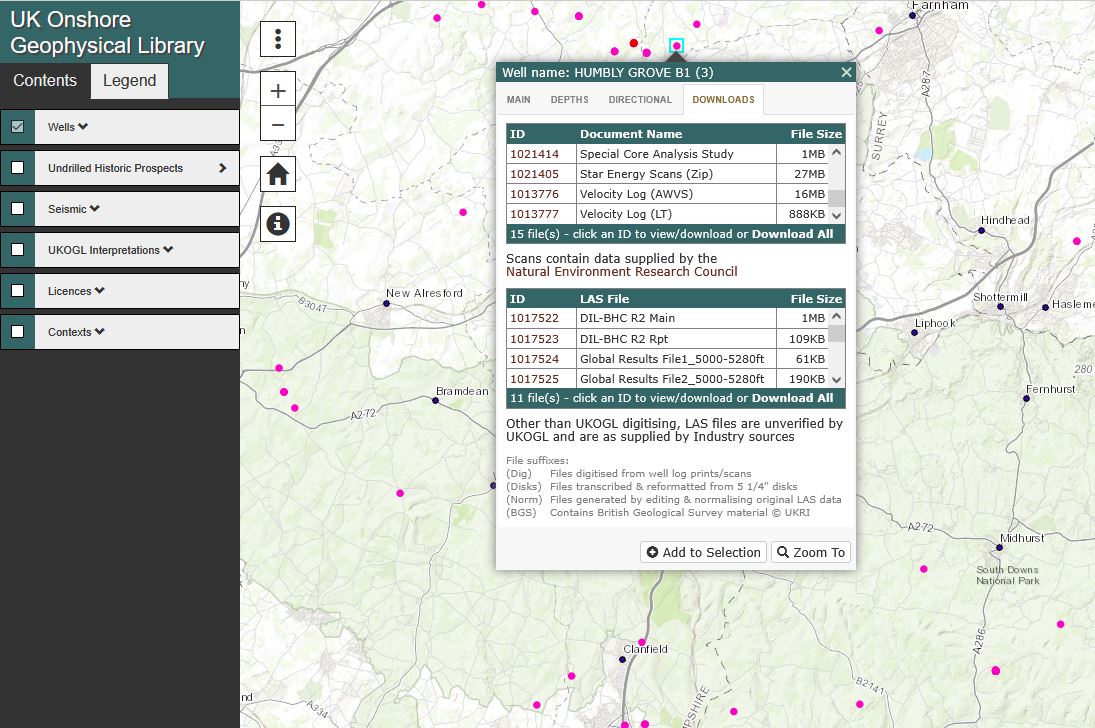
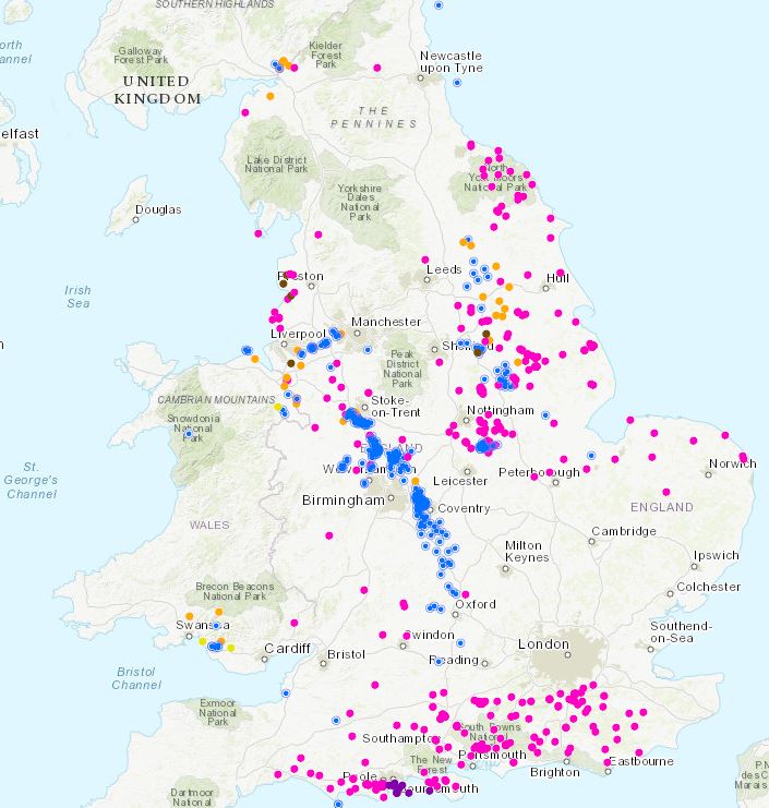
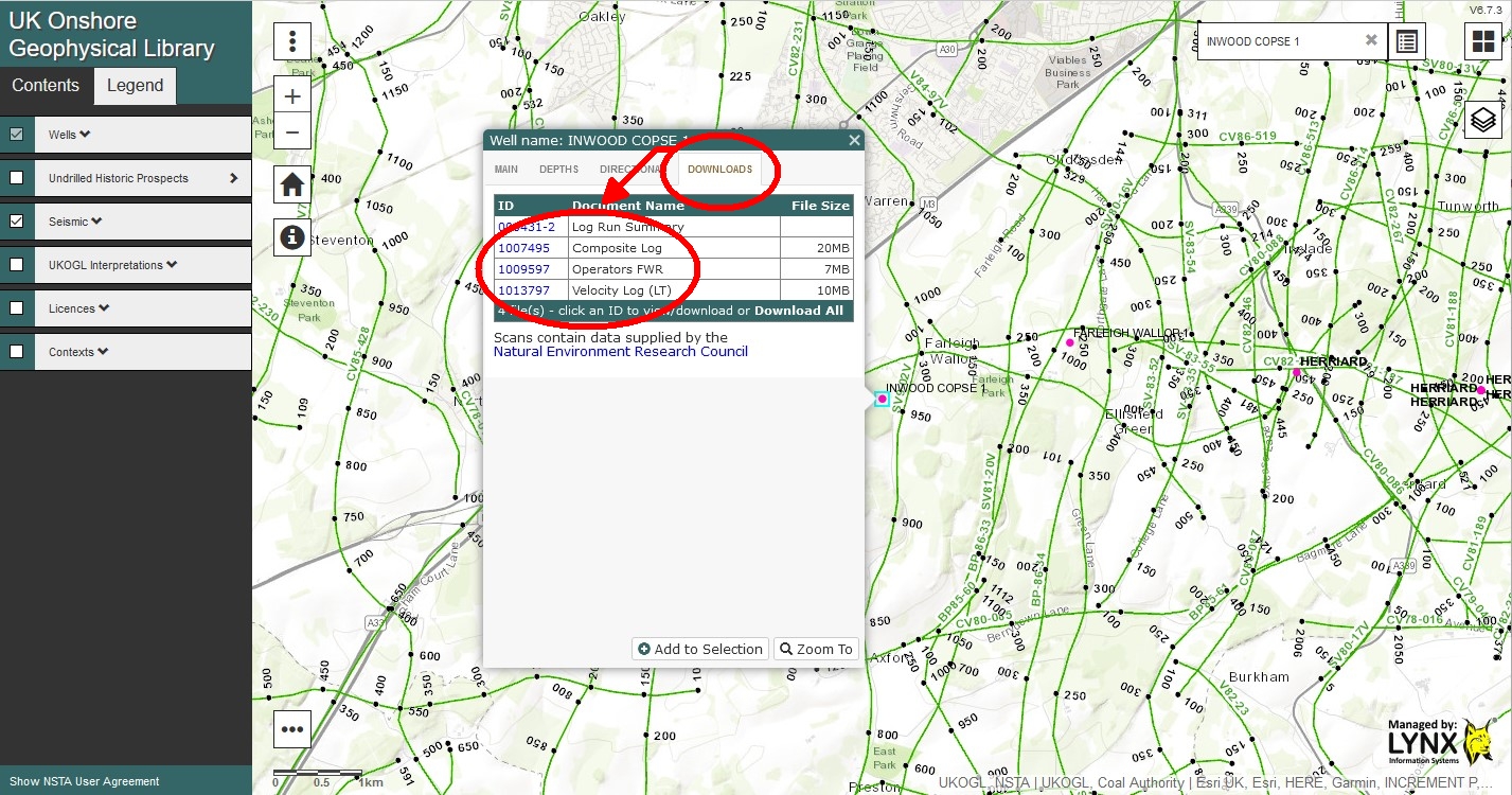
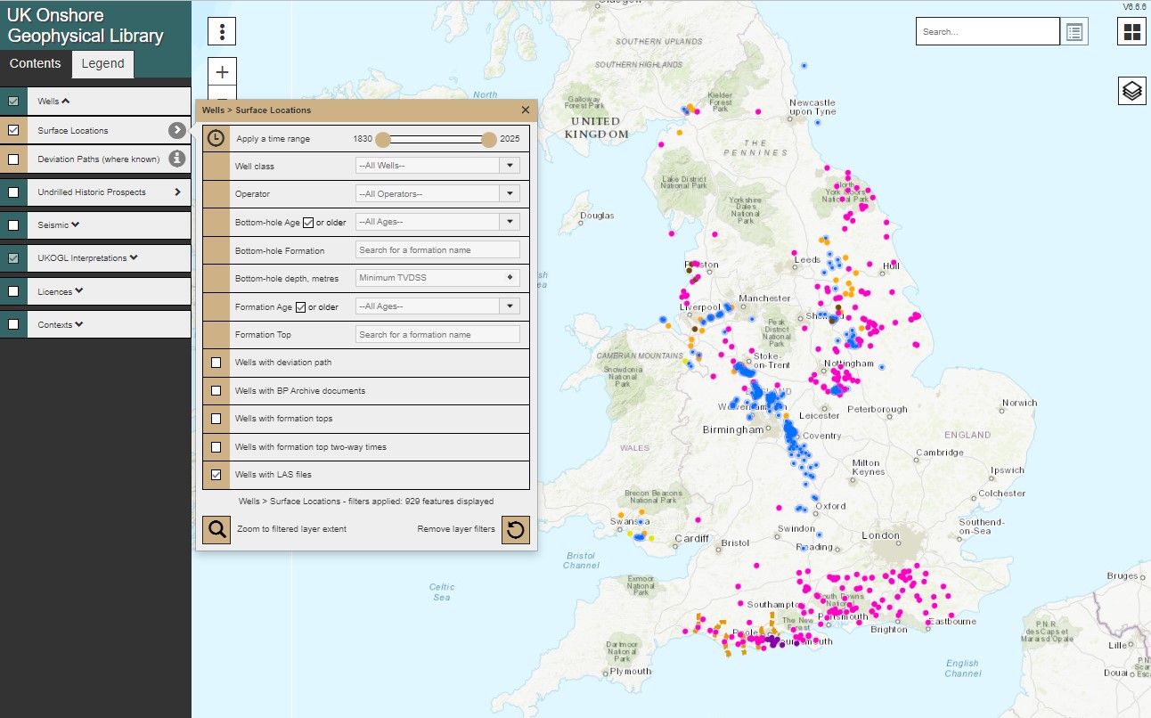
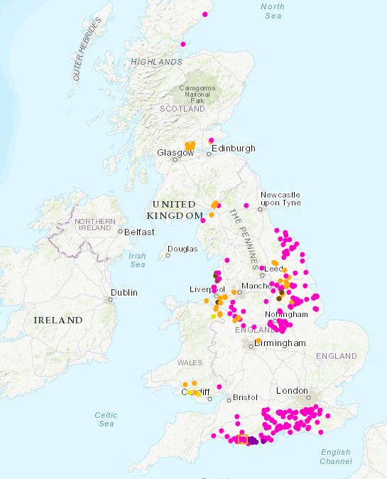
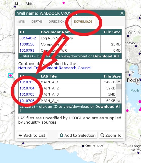
UKOGL is pleased to announce that it is in the process of adding the entire archive of scanned paper well logs and reports from UK onshore oil and gas wells which Star Energy has recently provided to the NSTA.  The archive comprises data from 812 wells and these data are being provided for each well in the form of a zipped file (labelled “Star Energy Scans (Zip)”) in the list of files under the “DOWNLOADS” tab of the drop-down menu that is accessed by clicking on the relevant well on the UKOGL website.

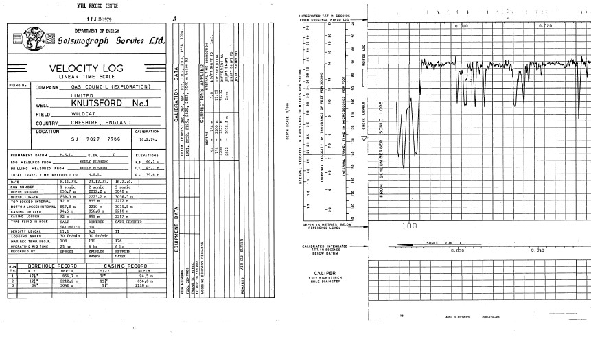
As part of this major well data release exercise, UKOGL is also uploading scans of logs, reports and other information donated by various companies over the past 30 years and held on file.  These data include core photos and analysis, geochemical and paleontological reports, VSP reports, testing reports, etc. and are available as separate items in the “DOWNLOADS” and “BP ARCHIVES” listings.

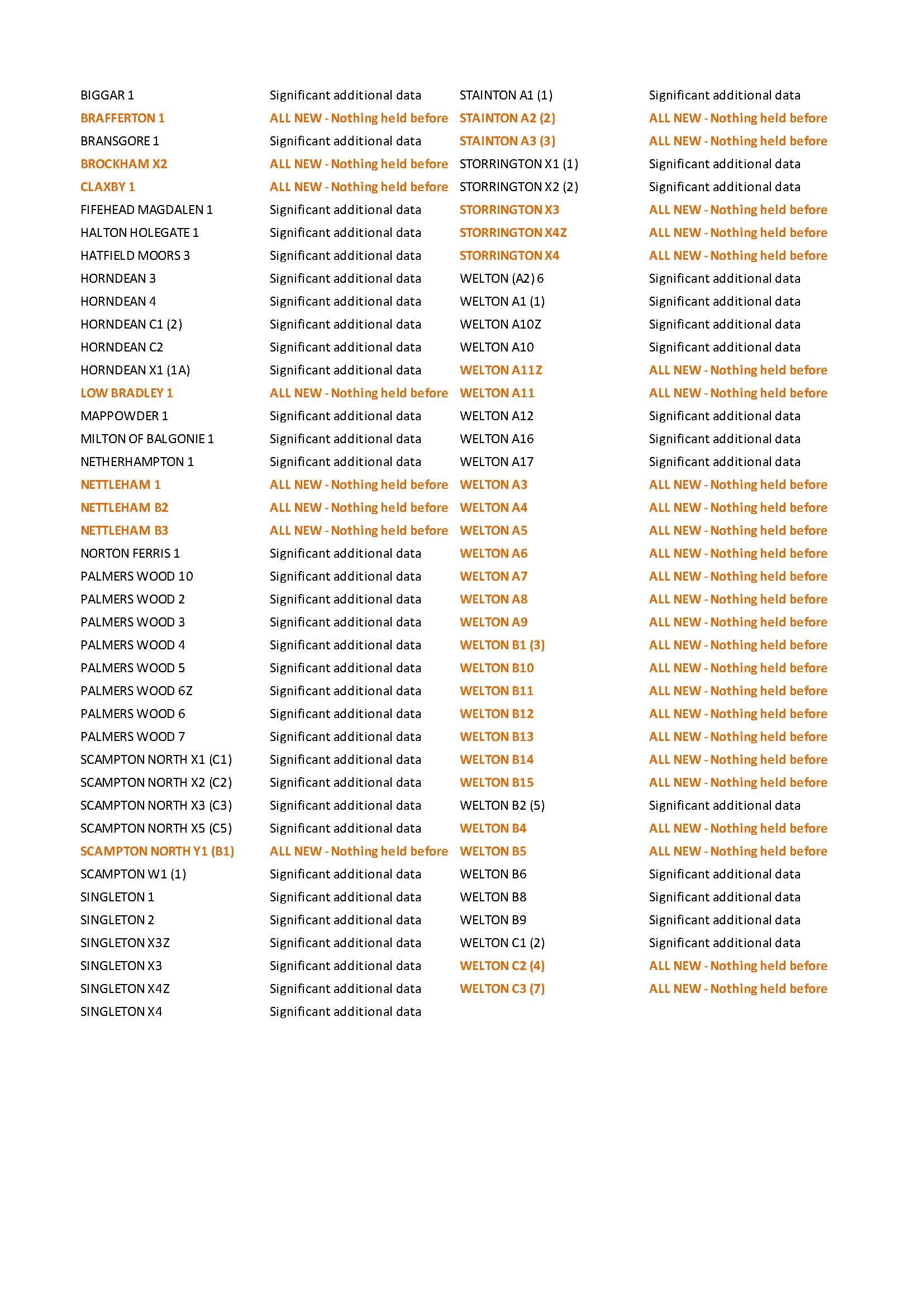
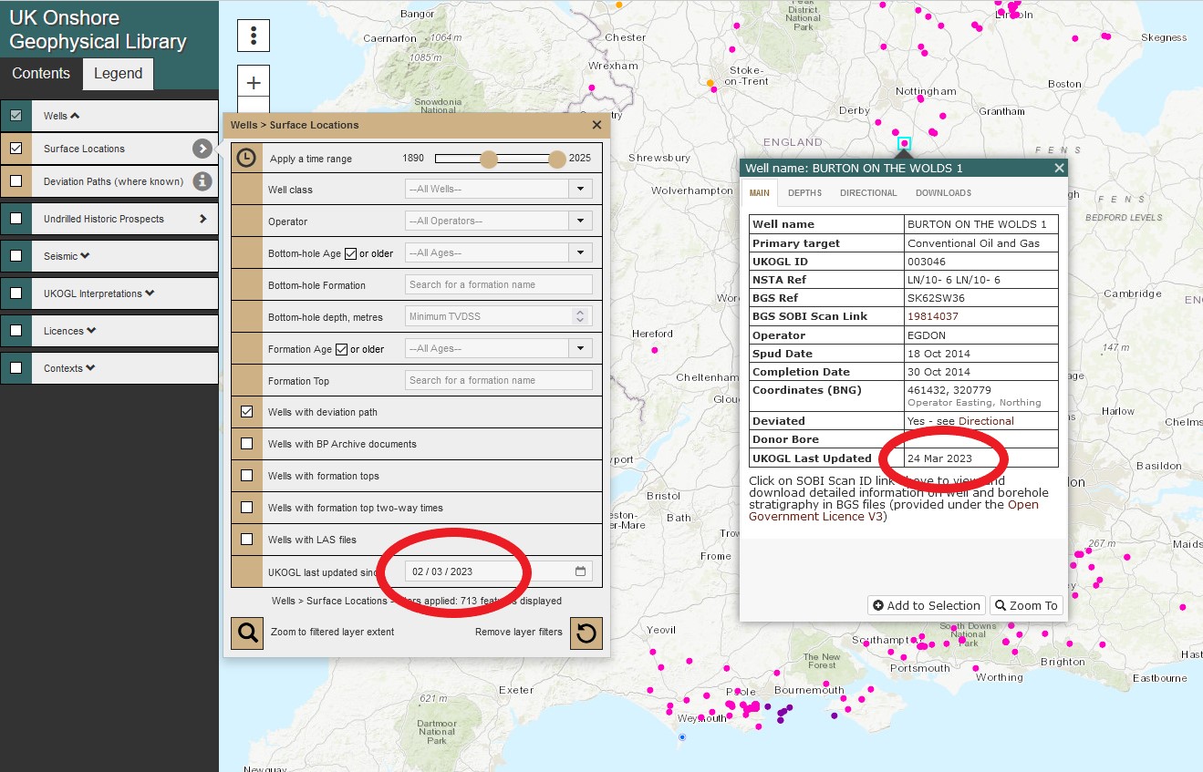
This major undertaking is still in progress and as of 20 March 2025 new data had been uploaded for 430 wells. UKOGL would like to record its thanks to Star Energy for making these data available for publication.

UKOGL provides further LAS files decoded from legacy STAR tapes

UKOGL is pleased to announce that Star Energy Group has kindly given it access to tapes containing legacy data from UK Onshore wells. These files have been transcribed by Ovation Data and Lynx Information Systems at UKOGL’s expense and have provided LAS files for 33 wells for which no data were previously available to UKOGL and a further 48 wells for which only partial data were previously available. All new data have now been uploaded to the UKOGL site (www.ukogl.co.uk) and are available for free download.

Separately, UKOGL has digitised logs of Guiting Power-1 and Winterborne Kingston-1 to generate LAS files.  These are also now available for free download.

UKOGL Onshore Map: Wells Layer – New Search Option

UKOGL have added a new filter option to the Wells layer of the Interactive Map to helps users when searching for UK onshore data. The wells displayed on the map can now be filtered using the ‘UKOGL last updated since’ option to only display the wells that have had new or updated data added to the site since the user defined date.

Wells that haven’t had any new data added after the user selected date will not be displayed. The new filter option can be also be combined with other available search options to further refine a query.

UKOGL provides listing of bottom hole temperatures measured in wells drilled for oil & gas in the UK Onshore

UKOGL has generated a listing of 1,838 temperatures vs depths recorded by logging runs and testing from well data for UK Onshore wells.  The listing can be downloaded in Excel format from UKOGL here. Note that downhole temperatures from logging runs are generally recorded shortly after drilling mud has been circulated and the readings are likely to be lower than actual formation temperatures.

BP Well Tapes

UKOGL is pleased to announce a significant enhancement to its digital well data offering,

Free to download via the interactive map.

BP has recently provided access to its extensive holding of onshore well tapes and, with  initial transcription expertise from OvationData, all tapes have now been decoded and converted by Lynx Information Systems to LAS files that can be read without the need for specialist software. 

As a result of this exercise, between February and April 2024 an additional 2,143 digital well log files have been added, with new data for 286 wells and boreholes now available for free access, as listed below.  The substantial costs of this exercise will be met from UKOGL existing cash reserves.

New well data available for download:

New Data Available From UKOGL in Warwickshire: Daw Mill 3D Seismic & Borehole LAS Data

UKOGL are pleased to announce that post stack seismic data and digital LAS data located over the Daw Mill 3D survey in Warwickshire have been added to the UKOGL archive. The data is available to download via the UKOGL interactive map.

The new Coal Authority data over the area displayed in the map below can be accessed for free under the Open Government Licence.

The available post stack data for the Daw Mill survey was originally recorded and processed in 2002, 2004, 2005 and 2011, expanding the coverage to the South West of the original 2002 survey with each subsequent year of recording.

The final 2011 merged and reprocessed post stack 3D data volume provides full seismic data coverage over the Daw Mill survey area.

In support of the available 3D seismic, LAS data is available to download for 32 of the 37 coal boreholes that are currently displayed by UKOGL over the area of the Daw Mill 3D survey, and this includes comprehensive logging suites for the newly added Eaves Green Lane BH and Keatley Pool BH.

These two new data sets add to the coverage that’s already provided by the 2D Coal Authority seismic data over this area of Warwickshire (displayed in the map below). All Coal Authority data is available to download for free from the UKOGL interactive map.

UK Onshore LAS Data – UKOGL download update.

UKOGL is pleased to announce important additions to the LAS files downloadable from its website:

– Key wells in Kent, Hampshire, Worcester Graben, West Midlands and Norfolk areas donated by Shell;

– Digitised logs in the Eakring area donated by Egdon Resources; and

– UKOGL digitised logs of older wells and boreholes in East Anglia, Herefordshire and Somerset

Negotiations are in progress to obtain LAS files for a significant number of additional wells from their original operators.

The UKOGL Trustees would like to express their gratitude for the assistance provided by all these companies in making available valuable datasets for open access by all parties.

LAS data coverage in Southern Britain available to download from UKOGL (October 2023)

UK Onshore Well Log Data – Velocity Log Images Available For Download From UKOGL

UK onshore velocity well log images are now available to be viewed and downloaded from the UKOGL interactive map.

The velocity well log images for Conventional Oil and Gas wells can be accessed via the well log information panel, where available the images can be accessed by the ‘Downloads’ tab.

Velocity well log images are now available for 422 onshore wells and where available, the data is comprised of:

  • Linear Time Logs (LT)
  • Air Gun Well Velocity Survey Logs (AWVS)
  • Calibrated Velocity Logs (CVL)
  • Seismic Calibration Logs (SCL)
  • Seismic Reference Survey Logs (SRS)
  • Adjusted Sonic Logs (ASL)

Onshore Well Data Coverage – LAS Data Update

UKOGL has recently added to its coverage of onshore well data that’s available to download from the interactive map.

Transcribed and reformatted from a collection of National Coal Board data, it was originally supplied on 5 1/4″ floppy disks and is now availble to download as LAS data files.

Onshore wells with available LAS data can be filtered to highlight the coveage and provide access to the files via the interactive map.

UK Onshore Well loactions with available LAS data (NCB data in blue)

This data is made available as part of the ongoing project to provide access to UK onshore LAS data via the UKOGL interactive map.

UKOGL ANNOUNCES THE PROVISION OF LAS DATA FOR OIL & GAS WELLS

IN ANOTHER MAJOR STEP FORWARD IN THE PROVISION OF ONSHORE DATA, UKOGL ANNOUNCES THE PROVISION OF LAS DATA FOR OIL & GAS WELLS

Following the release of UK Onshore oil & gas well composite logs via the UK Onshore Geophysical Library interactive map, UKOGL is pleased to announce the next stage of its initiative to provide simple free access to deep borehole information. UK onshore digital well data in LAS format can now be downloaded without charge. All wells with available LAS data can be filtered, selected and the data downloaded via the interactive map as part of UKOGL’s ongoing project to make more onshore data freely available. As more LAS data become available the UKOGL map will be updated to display the increased onshore data coverage.

UKOGL Well LAS Data Coverage

The coverage of UK onshore wells with LAS data can be filtered and displayed separately to aid in data selection via the interactive map ‘Contents Menu’ selection tick boxes.

UKOGL Interactive Map ‘Contents Menu’

From the ‘Contents Menu’ select: ‘Wells’ – ‘Surface Locations’ – ‘Well with LAS’ this will display the latest LAS data coverage.

The ‘Legend Menu’ provides details on the well type displayed, LAS data is available for conventional oil and gas exploration wells, as well as selected coal bed methane and shale gas wells.

From the displayed coverage zoom to a well over the area of interest and select the well spot.

Well Spots With Available LAS Data

To access the LAS data select the ‘Downloads’ Tab from the information panel to display a list of available LAS files, complete with a summary of the included curves in each file.

LAS Data Listing With Available Curves And File Sizes

To access the LAS data select the ID hyperlink that lists the curves in each available file, once selected  the curves will be displayed as an ASCII text file.

LAS File Data Display

To download the data select the ‘Download file’ hyperlink.

Please note that all LAS files are unverified by UKOGL and are ‘as supplied’ by industry sources.