UKOGL will be exhibiting on Saturday November 7th at the Festival Of Geology, University College, London. Please come and visit us in the Discovery Room and find out more about the direct support that we provide to academic institutions.

UKOGL will be exhibiting on Saturday November 7th at the Festival Of Geology, University College, London. Please come and visit us in the Discovery Room and find out more about the direct support that we provide to academic institutions.
UKOGL have recently embarked on a major project, in support of the British Geological Survey, to compile a fully reconciled digital Post Stack archive of Coal Authority seismic surveys, along with a definitive master catalogue of this geophysical data as acquired by the National Coal Board (NCB) and its successor, the British Coal Corporation (BCC).
Even though the project is in its early stages, UKOGL is able to make this data available for selection and purchase through the On-Line Map, although there may be a short time lag to supply surveys not on the shelf at time of request. Over time, as the archive is completed, the list of surveys will be refined and high resolution JPEG images added to the website.
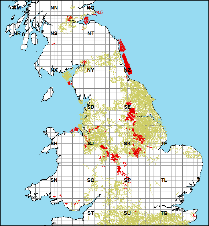
This coverage, detailed in red below, offers a valuable infill to the UKOGL archive of data recorded by Exploration Companies.
The Mosaic Archive, managed on behalf of the Oil & Gas Authority, consists of released Licence Applications, Field Assessments and Licence Activity & Evaluation Reports. After successful negotiations between UKOGL and Mosaic Information Solutions, it has been agreed that this important data set is to be transferred into the UKOGL archives.
In the longer term, individual reports will be made freely available through the UKOGL web site, however during the transfer and re-classification, please contact UKOGL for access and further details.
The BP survey ( BP842DL027) recorded in 1984 has recently been added to the UKOGL archive. This survey consists of 25 2D seismic lines (totaling 288km in length) and consists of both Pre & Post stack data, SP navigation, scanned hard copy images and supporting acquisition data.
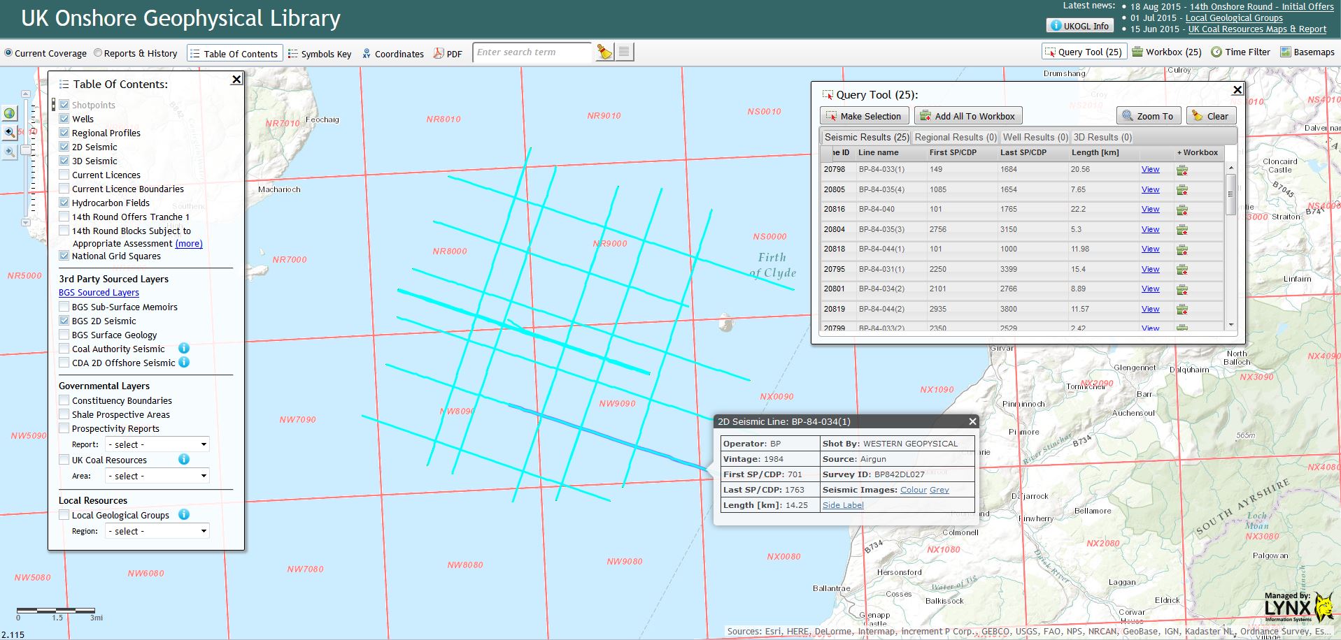
BP 1984 Firth of Clyde 2D seismic Survey
The survey is located in the Firth of Clyde but was recorded by BP over their Licence: PL262
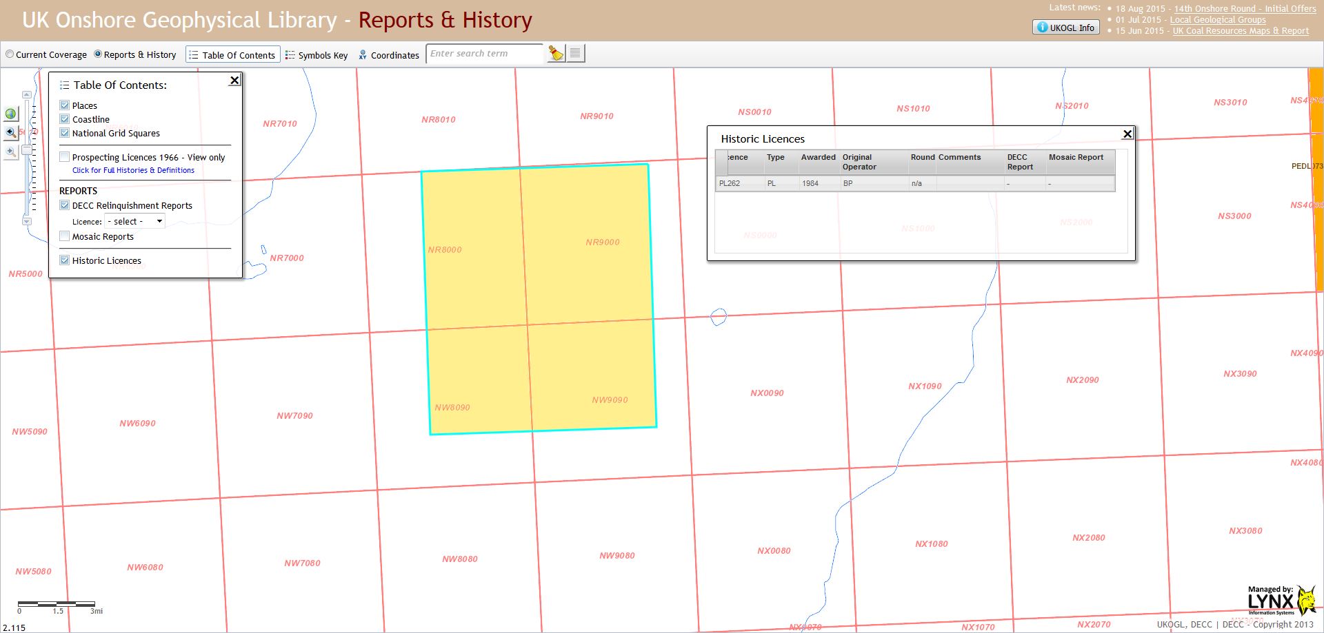
Location of the 1984 BP Licence PL262 in the Firth of Clyde.
For more information about this or any of the other surveys or data available from UKOGL, please contact us here
The OGA announced today that 27 Onshore Blocks were being formerly offered to applicants as part of the 14th Round, with a further 132 Blocks being considered pending an additional detailed assessment under the Conservation of Habitats and Species Regulations 2010.
Layers of both sets of Blocks are available to view through the UKOGL on-line map.
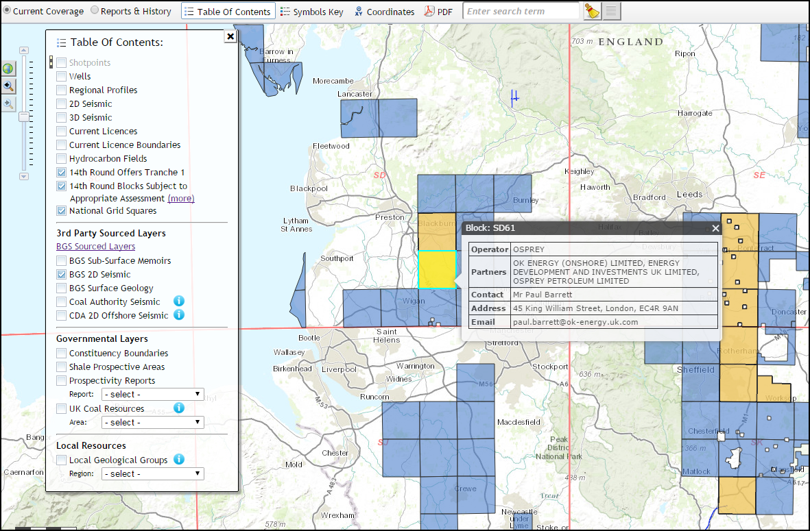
The formal announcement from the OGA can be found here, with associated downloads available both here and here.
If you hold an active interest in Geology and wish to join like-minded enthusiasts for field trips and talks, there may be a local group or society already established in your area. Our new map layer allows you to select a region, to find a comprehensive list of organisations and their website details.
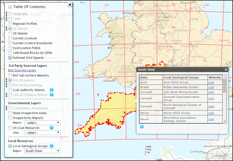
Equally, if you would like to let us know of any groups not currently listed, then we would be happy to add them to our links. Please contact us here with the name of your organisation, your general catchment area and website details.
With the kind permission of both the Oil & Gas Authority and the British Geological Survey, we are now able to display a series of UK Coal Resources Prospectivity Maps, along with an associated report. This study was undertaken by the BGS in 2004 and was commissioned by the then Department Of Trade & Industry as part of their Cleaner Coal Technology Transfer Programme.
The BGS looked at the potential exploitation of coal resources by both conventional mining technologies (including underground and opencast mining, coal mine methane and abandoned mine methane) and also through new technologies such as underground coal gasification (UCG), virgin coalbed methane (VCBM) and coal seam-related carbon dioxide (CO2) sequestration.
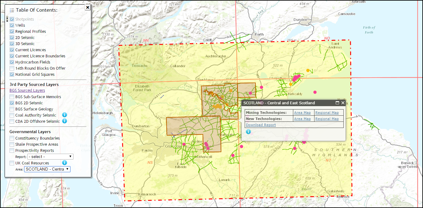
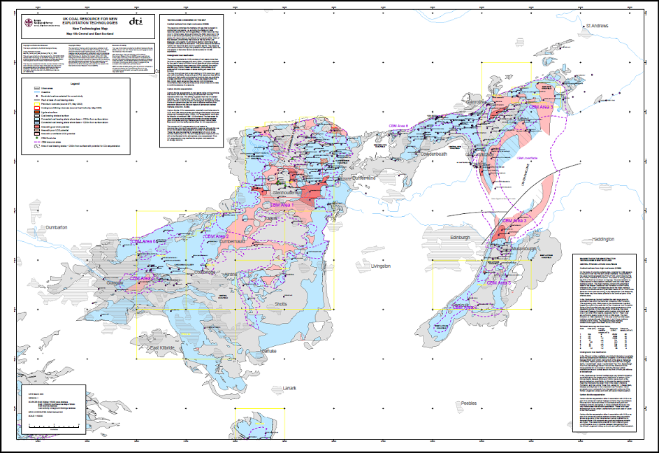
For full information and for the supply of an interactive DVD, please contact the BGS through their Enquiry Service
In support of the OGA and the Well Data Release Agents, we are pleased to announce that Composite Log headers are now available to view through the UKOGL interactive map. We have also taken this opportunity to refresh the look of the well data information presented on the site.
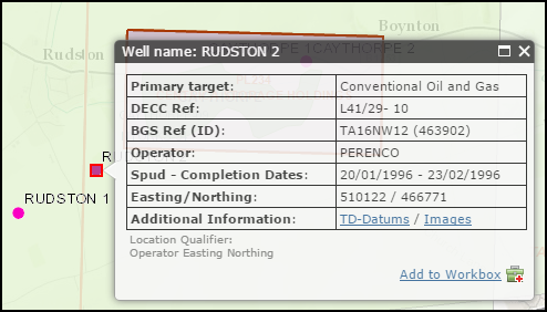
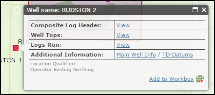
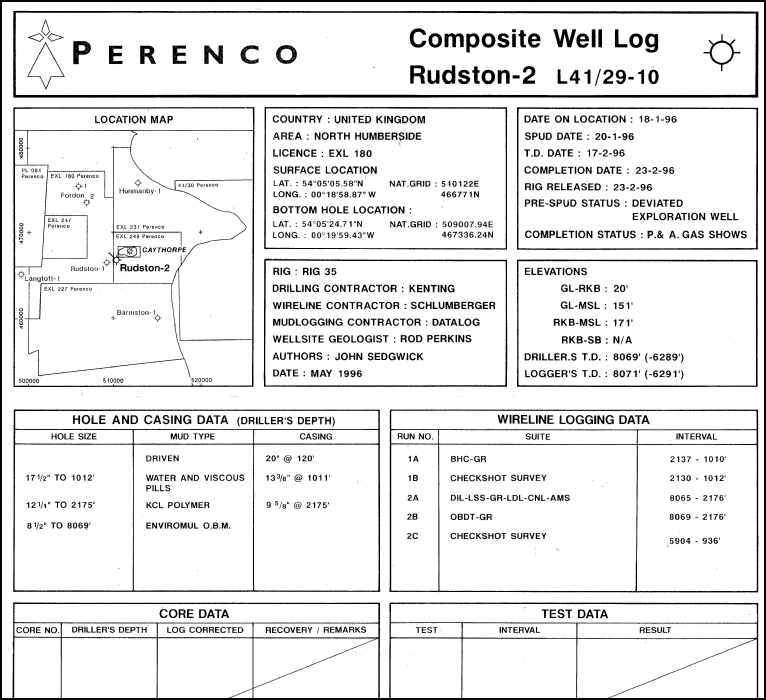
All well details are provided for information only. For the supply of scanned, digital and hard copy UK onshore well data, please visit either the British Geological Survey or the OGA’s formal Well Data Release Agents
Come and meet The UK Onshore Geophysical Library (UKOGL), who will be attending the Lyme Regis Fossil Festival again this year. As part of the bicentennial celebrations, UKOGL will be demonstrating the William Smith Interactive Website at the festival, a free-to-use site celebrating the first geological map of England and Wales published in 1815. (www.strata-smith.com) by William Smith.
See how accurately the very first geological map compares to today’s modern versions, find out about the geology under your feet using the UKOGL website (www.ukogl.org.uk), children can take part in our William Smith colouring competition to try and win a fossil.
We hope to have an original version of one of William Smith’s early maps on display at various times over the two days, so come and drop by our display at the Fossil Festival for more information or to see a demonstration of the ‘free to use’ William Smith and UKOGL websites.
UKOGL at the Lyme Regis Fossil Festival – Attending on the 2nd – 3rd May 2015
