The 2016 OGA UK onshore seismic data release packages are now available to be downloaded via the UKOGL Interactive Map website.
The UKOGL Interactive map provides immediate access to the onshore reprocessed data packages and the post stack 2D and 3D SEG-Y data can be viewed before downloading using iSeisview – An online seismic data viewer developed by Lynx Information Systems Ltd. that enables the user to interactively view the Post Stack SEG-Y in real-time.
Only the reprocessed 2D post stack SEG-Y and 3D data that forms part of the 2016 OGA data can be viewed in iSeisview.
The seismic viewer developed by Lynx enables SEG-Y data in 2D or 3D inline and crossline profiles to be displayed interactively in a web browser and allows the user to select display styles, zoom levels, horizontal and vertical scales and trace amplitudes of the SEG-Y data.
Access to the 2016 OGA onshore data packages via the UKOGL Interactive map does not require a login.
The freely available government funded reprocessed onshore data is comprised of UK onshore reprocessed 2D post stack SEG-Y data, SEG-Y gathers, navigation data and supporting processing reports located over three onshore areas of the UK:
- Isle of Skye
- Solway Firth
- South Coast of England.
The original processed 3D Wytch-Farm-98 post stack SEG-Y data is also available as part of the South Coast data set with all inlines and crosslines available to be assessed interactively using iSeisview before downloading.
How to Access the Data
Access to the OGA Onshore data packages is via the contents sidebar on the UKOGL Interactive Map as indicated below.
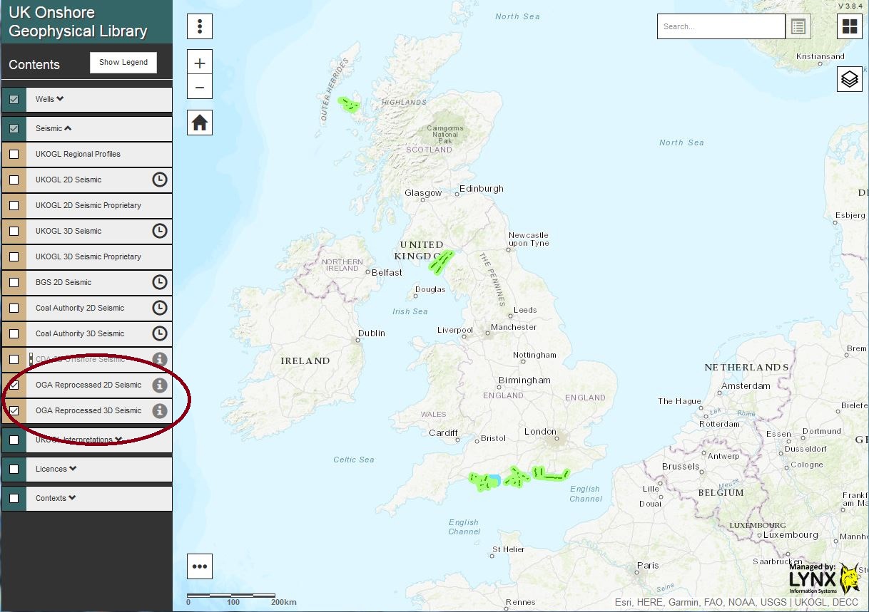
2016 OGA Reprocessed 2D and 3D Seismic displayed via the ‘tick’ box
The reprocessed 2D Post Stack SEG-Y data and 3D Post-Stack SEG-Y survey can be viewed immediately by selecting the “Live Seismic Viewer” option to assess the data using iSeisView or, by selecting the “View and Download Files” option a Virtual Data Room developed by Lynx will be launched for each area to easily access all onshore files that have been made available as part of the 2016 Government-Funded UK onshore reprocessed data packages.
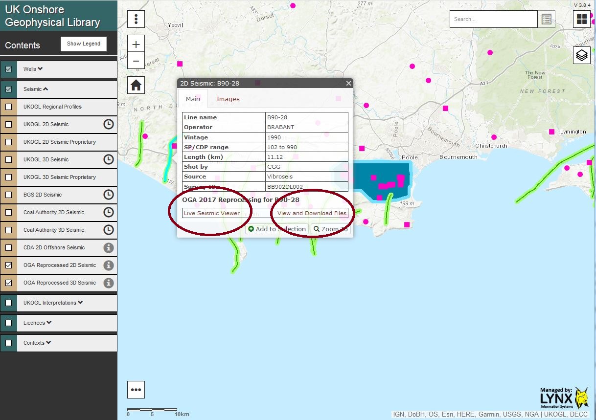
Following line selection – Option to interactively view the available SEG-Y data or access and download the data
The “View and Download Files” option launches the Lynx Virtual Data Room: 2D lines can be selected and the SEG-Y data viewed interactively via iSeisview either by selecting each line from the “Map” or via a “2D Seismic Line List” view.
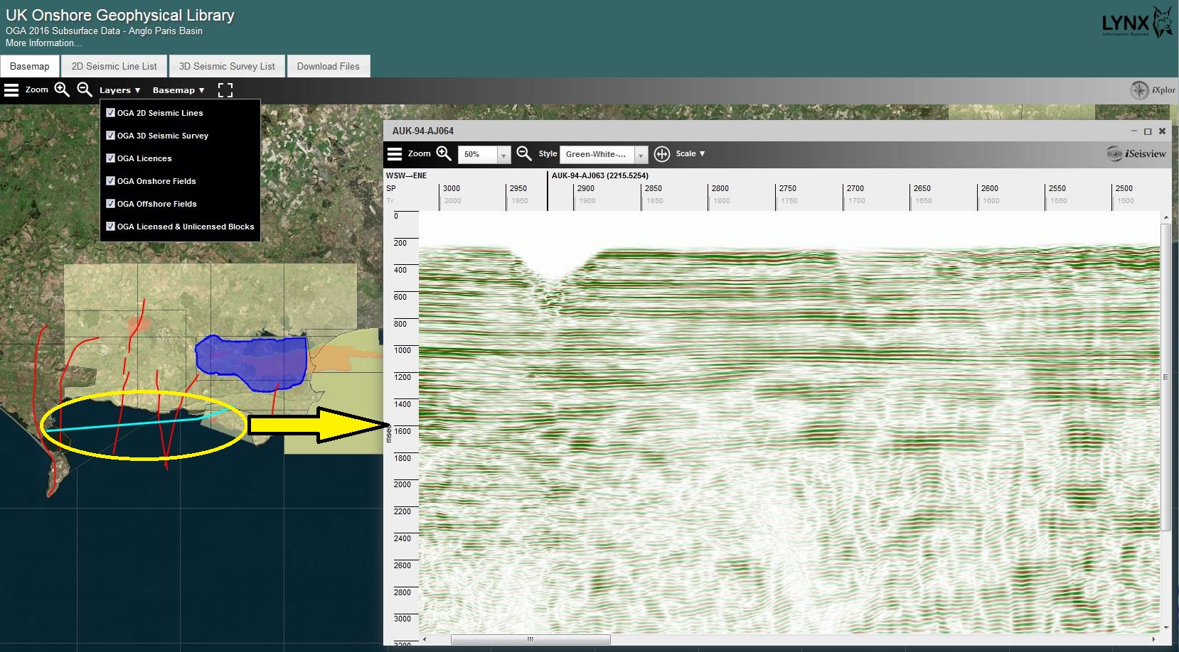
Virtual Data Room – The selection of a 2D line enables the SEG-Y data to viewed interactively using iSeisview
To view inlines or crosslines from the available 3D survey in iSeisview, ‘hover’ over and ‘click’ on the 3D survey and then use the left mouse button to select an inline or the right mouse button to select a crossline.
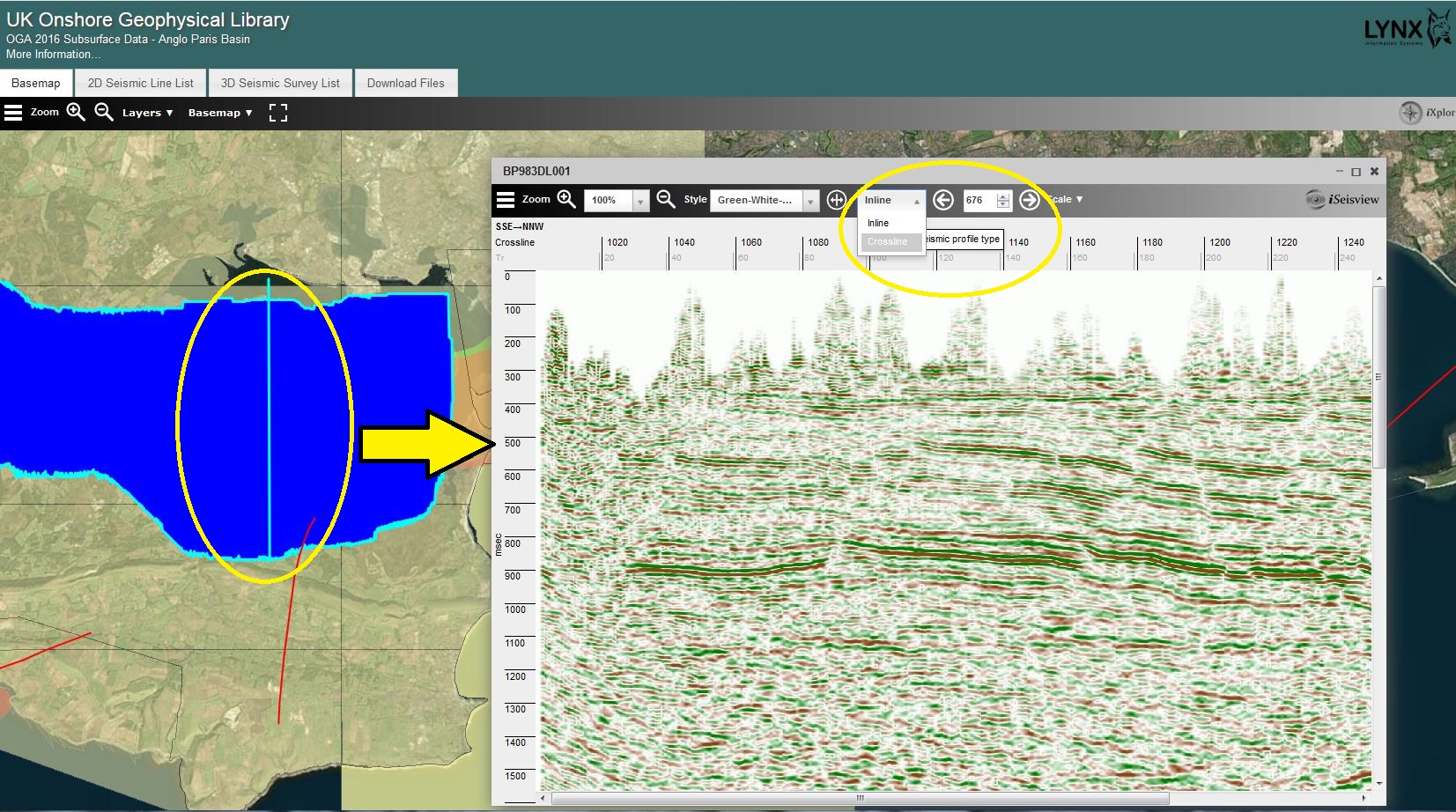
The left mouse button is used to select an inline to view via iSeisview from the 3D survey.

The right mouse button is used to select a crossline to view via iSeisview from the 3D survey.
EBCDIC header information, inlines and crosslines can also be selected using the options via the SEG-Y viewer.
To download the available data select the “Download Files” tab. The data for each package can be quickly and easily selected for download using the ‘tick’ boxes. Data for each area and line has been grouped and “pre-zipped” in to associated processed versions, SEG-Y gathers, reports, velocity files and navigation data files to streamline access to the data packages.
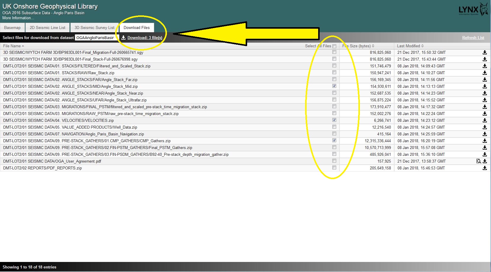
Select files and download via the “Download Files” tab.
The terms of the use of the data as supplied as part of the 2016 OGA data release packages can be found in: Oil and Gas Authority user Agreement.
The 2016 offshore data packages are available from download via the UKOilandGasData portal.