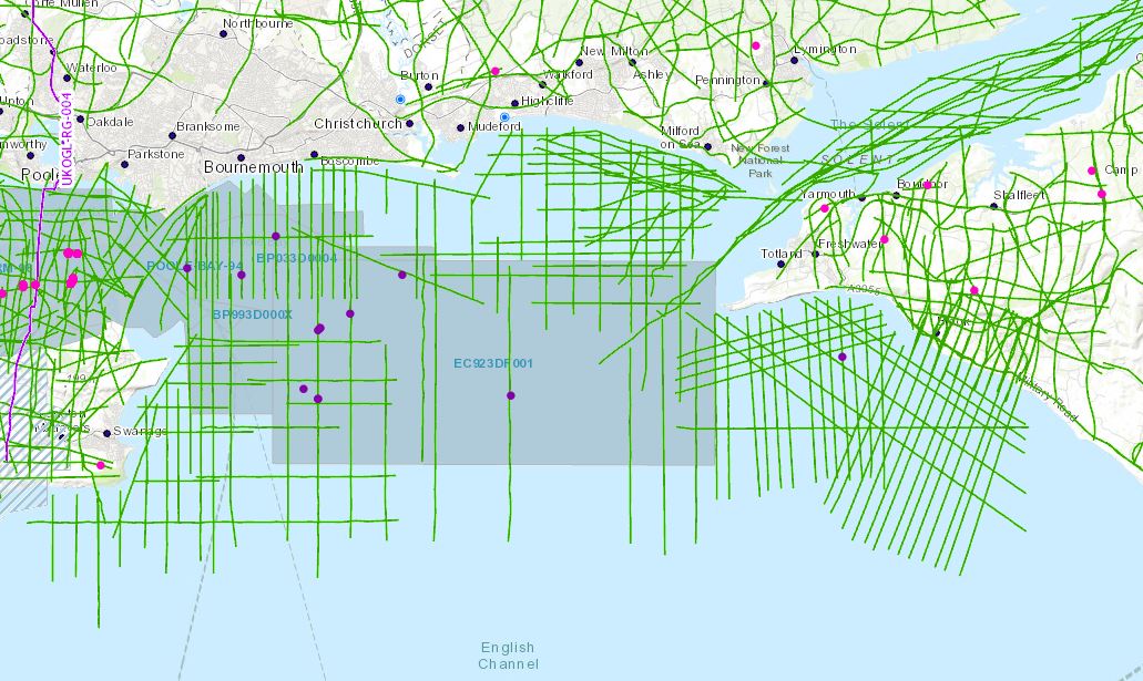
In support of the recent release of 2D, 3D seismic and well data located over Poole Bay, UKOGL have made available for download a selected set of data located offshore to the southwest of the Isle of Wight which provides greater coverage to tie this newly designated landward area to eastern onshore data. 11 of the 37 lines in the OX98-90 survey run onshore to enable seamless interpretation from onshore to offshore. The data set includes reprocessed 2D versions not available in the UK National Data Repository (NDR).
Instructions on how to access this data can be accessed via the Poole Bay Blog post here.
The intention of this exercise is to make it easier for interested parties to study this key area of British Geology. Additional offshore 2D data is available from the NDR but coordinates will need to be transformed to OSGB to match.
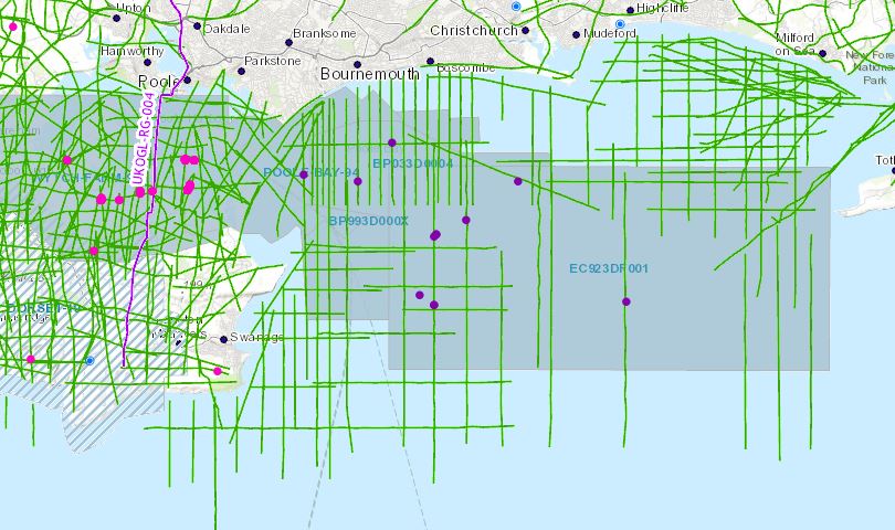
Now that Poole Bay has been designated a “Landward” area, UKOGL has archived and made available for download a selected set of data located in OSGB (National Grid) projection to enable seamless interpretation from onshore to offshore. These data include reprocessed offshore 2D and 3D versions not available in the UK National Data Repository (NDR). Well data, including LAS files, have been copied from the NDR database and relocated in OSGB.
The intention of this exercise is to make it easier for interested parties to study this key area of British Geology. Additional offshore 2D data is available from the NDR but coordinates will need to be transformed to OSGB to match.
Seismic Data Access:
The seismic data can be accessed by selecting the individual 2D lines and 3D surveys or by using the ‘Area Selection’ tool. The seismic data that is available for each line or survey is listed under the ‘SEGY’ tab of the information box. If interpreted versions are available they will be shown under the “IMAGES” tab of this box.
Well Data Access:
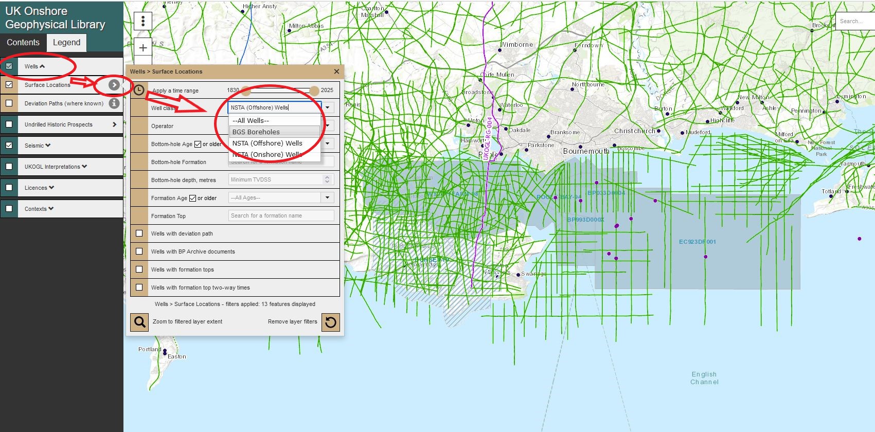
Onshore and ‘Offshore’ wells are presented as separate data layers and can be displayed via the options in the Contents Panel – Wells>Surface Locations>Well class>NSTA (Offshore) Wells.
Individual well layers can be displayed and made available for selection by switching each layer ‘on or off’ to filter the well presentation.
To access the available well data, multiple wells can be selected and highlighted using the ‘Area Selection’ tool or individually by selecting just the well spot location.
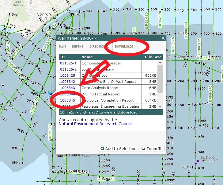
Select the ‘Downloads’ tab in the well information panel to access the list of available files.
To access, view and download data click on the ‘ID’ information box and follow the instructions provided.
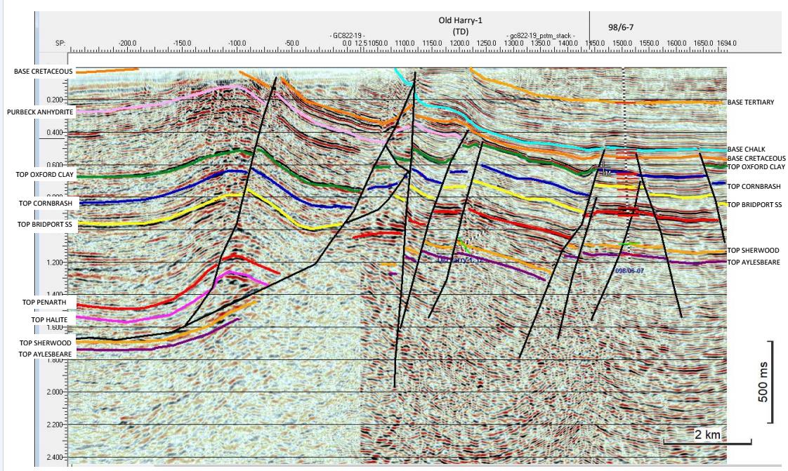
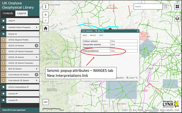
UKOGL have implemented a new website feature that provides direct access to over 2400 interpreted onshore seismic images.
The interpreted images have been compiled and collated from reports currently held by UKOGL and can be viewed and downloaded alongside the seismic images that are already available for each onshore line on the website.
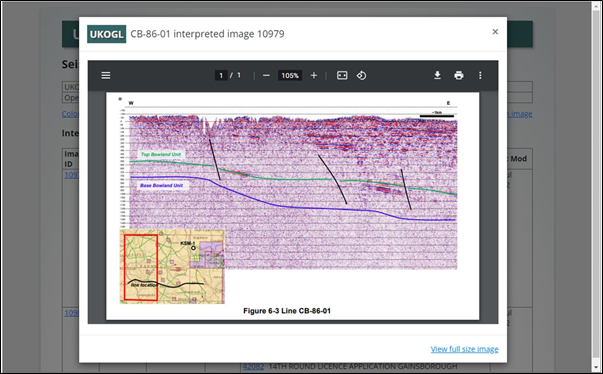
The interpretations may be based on pre- or post-drill prospect assessments and well results may have indicated that changes are necessary. For additional context please view the associated source reports where available, or the drill dates, finalised tops and times for any wells associated with the prospect
Neither the UK Onshore Geophysical Library nor the original interpreters warrant the integrity of these data and will not be liable in contract or in tort for any loss, damage or expense of any nature suffered by the user as a result of the use of, or reliance on, these data
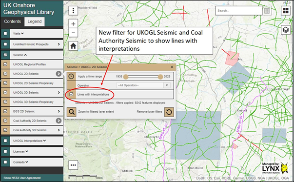
The seismic lines that have interpretation images available can be selected and their locations displayed via the ‘Contents SideBar > UKOGL2D Seismic’ tab:
To access the available interpretations, highlight the displayed seismic line displayed on the UKOGL interactive map and then select the ‘Interpretation – view’ option where available:
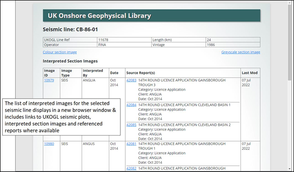
A new window will open and display a list of all available interpretation images and associated source reports for the selected line:
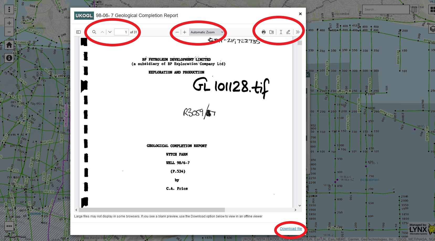
Click on Image ID number to display the interpreted line; click on Source Report number to see the report from which the interpretation was extracted.
All available interpreted images can either be viewed on screen….
….. or downloaded and viewed outside your browser by selecting the ‘Download’ link on the listings screen:
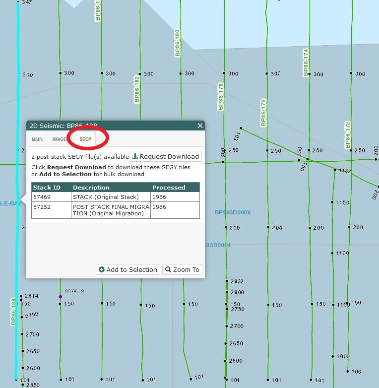
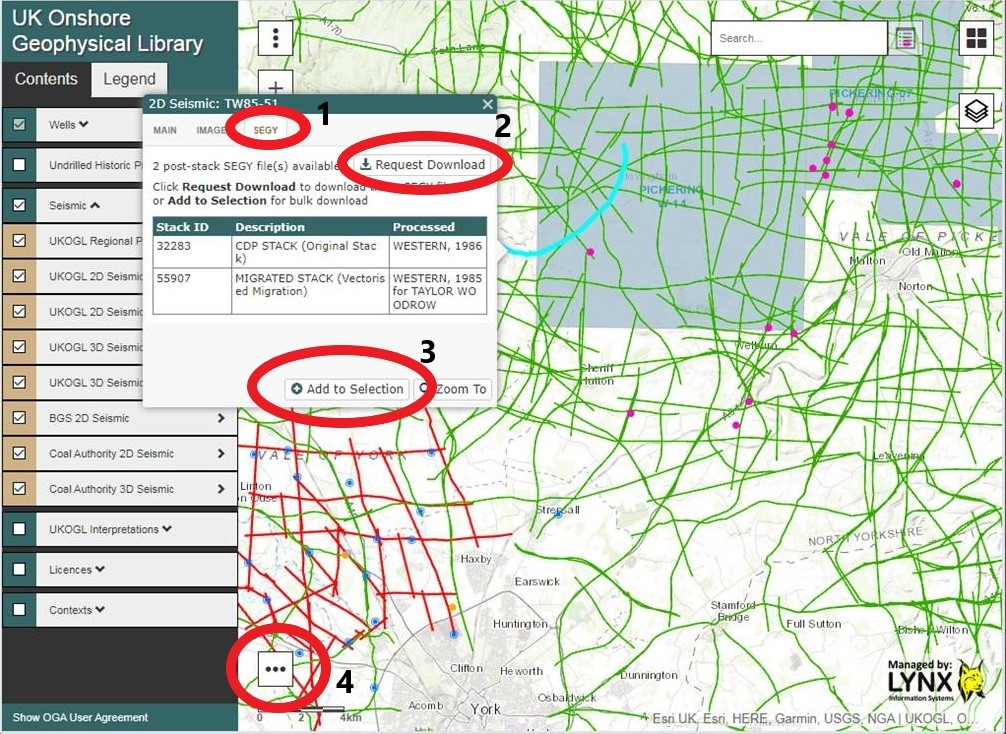
UKOGL have implemented new website features that provide more information about the post stack SEGY data archived in UKOGL and allow direct download from the website. Non-commercial, including academic, users have the ability to download at no cost and with no paperwork after approval of their status by UKOGL; commercial users will also be able to download directly after agreeing the cost and signing a licensing agreement with UKOGL.
Access to information and available post stack data for individual lines can be made via a new ‘SEGY’ Tab option (1) on the seismic line query pop-up box:
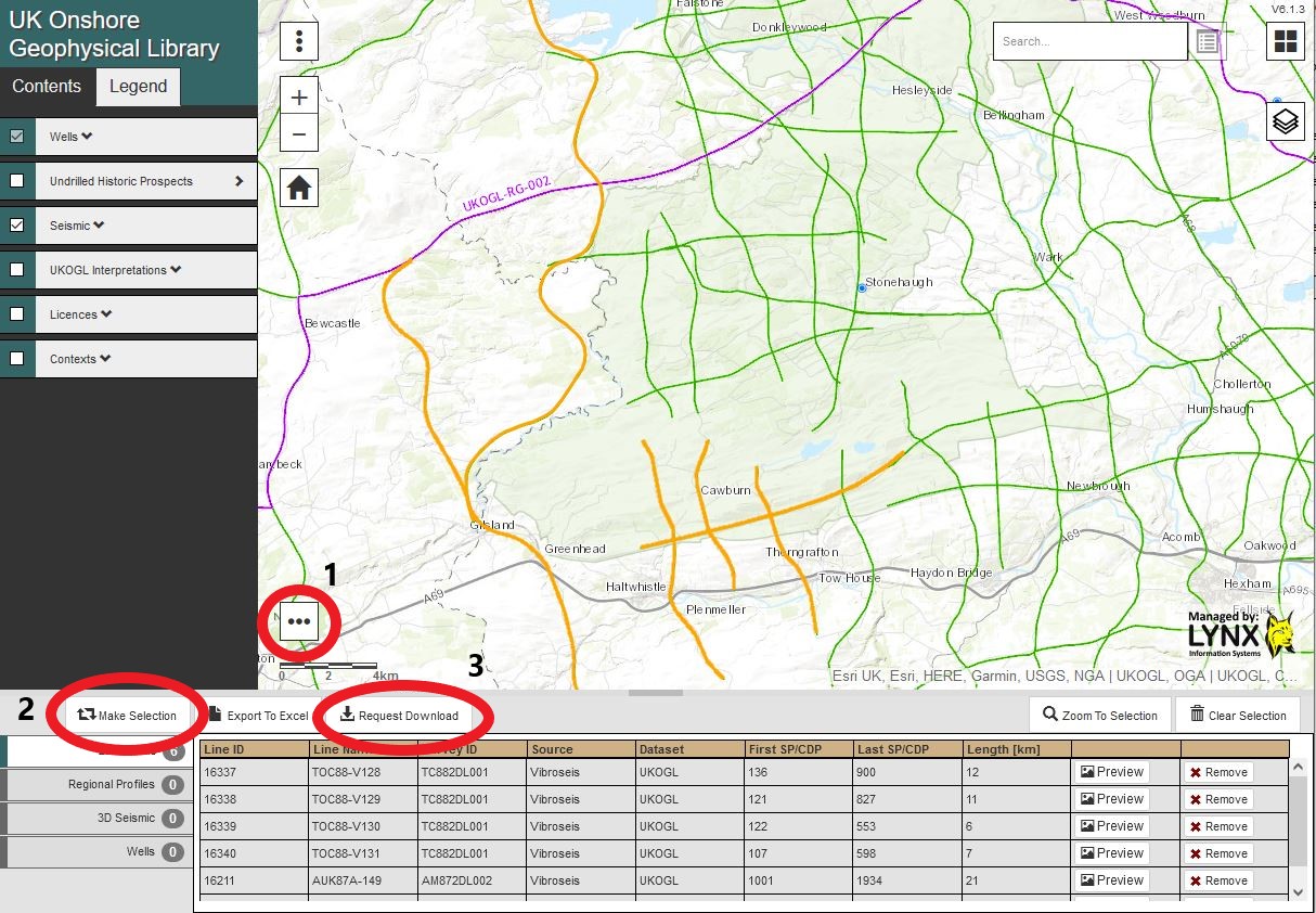
Select the ‘Request Download’ button (2) if only a single line is required or select the ‘Add to Selection’ button (3) to select multiple lines and then access your selection via the ‘Selection’ button (4) on the bottom-left of the map screen
Multiple line selections can be made in a single pass via the ‘Selection’ button (1) (see image below), then using the mouse to select the required seismic lines on the map via the ‘Make Selection’ button (2), up to 100 lines can be selected and requested via the ‘Request Download’ button (3).
Selecting the ‘Request Download’ button creates a ‘pop-up form’ that has to be filled in with details about the request.
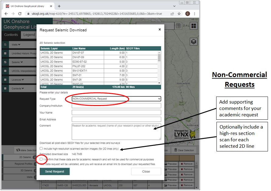
For non-commercial requests,select the request type ‘ NON-COMMERCIAL’, enter the requested details and confirm that the data is to be used for non-commercial purposes. Please note that, for simplicity, if only scanned sections are required it is still necessary to request the SEGY first: the scans will be sent with the SEGY, which can be discarded if not required (see below)
By selecting ‘Send Request’ for a non-commercial data request an email will be sent to Beneath Britain for assessment and request approval. Once approved, an email will be sent to the email address supplied on the form that will contain a download link to access the requested data.
Both 2D lines and 3D surveys can be requested as part of your non-commercial request.
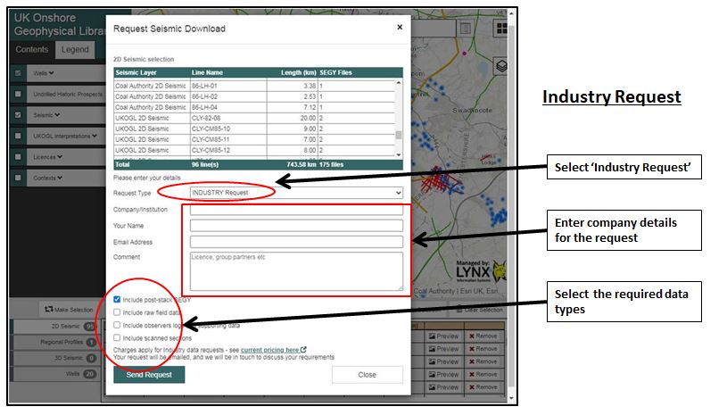
For commercial requests select the request type ‘Industry Request’ enter the requested details and confirm the data types to be requested:
After all relevant details have been entered, select ‘Send Request’ to be provided with a quote via return email that will provide a license agreement and details of the cost, based on the revised rates announced in January 2022. Once signed, they will then be able to output the selected data based upon the details provided in the form.
UKOGL are pleased to announce that the Reconnaissance Licence Fee entitling access to post stack seismic data archived in the Library has been reduced to £7.50 per km.
This reduction is also reflected in the cost of any new data requests that are licensed under a Full Agreement, which are now reduced to £42.50 per km
UK Onshore Geophysical Library, c/o Lynx Information Systems Ltd, 84 Coombe Road, New Malden, Surrey, KT3 4QS.
The contact telephone number 0208 780 2634 and all contact email addresses will remain unchanged.
We apologise for the inconvenience that the relocation of our office caused resulting in the website and interactive map being offline during this period, but we are now fully operational following the move.
There have been a number of major powercuts affecting the UKOGL office and the surrounding area this morning.
Unfortunately this has affected the IT network that hosts the interactive map, we apologise for the loss of service and hope to have the map back up and working very soon.
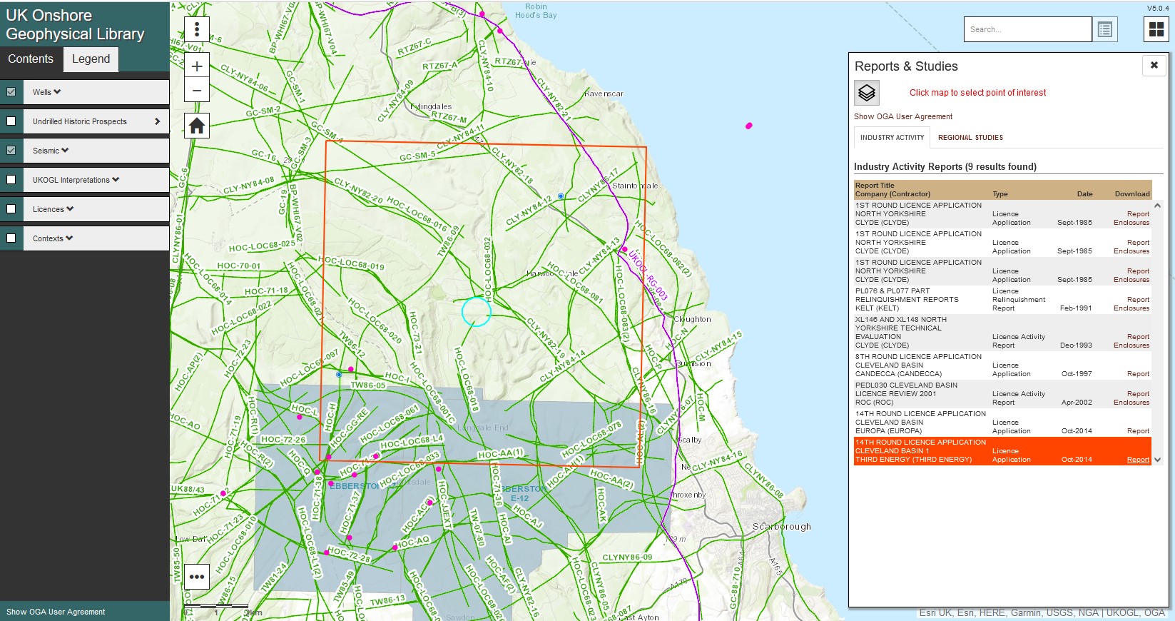
The 14th Onshore Licence Applications have been released by the Oil & Gas Authority and can now be accessed via the UKOGL website.
Applications can be searched and downloaded either geographically via the ‘Catch all reports’ icon on the interactive map or via a text based search using the ‘Industry Activity Reports’ link on the UKOGL home page.
Dr Malcolm Butler, Chair of UKOGL since its foundation in 1994 and joint
Director of Beneath Britain since it was established in 2018, has been
appointed an Officer of the Order of the British Empire (OBE) by the
Queen in the 2021 New Year’s Honours List for services to Education,
Research and Development.
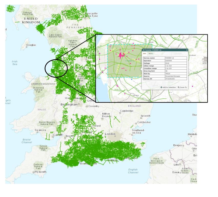
One new seismic surveys has been released onshore in January 2021 and is now available through UKOGL. The Formby-16 3D seismic survey is located onshore in Lancashire.